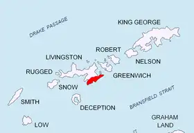
Location of Tangra Mountains on Livingston Island in the South Shetland Islands.
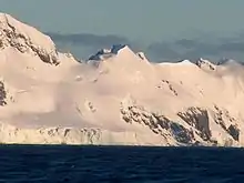
Karlovo Peak from Bransfield Strait.

Topographic map of Livingston Island, Greenwich, Robert, Snow and Smith Islands.
Karlovo Peak (Bulgarian: връх Карлово, romanized: vrah Karlovo, IPA: [ˈvrɤx ˈkarɫovo]) is a 300 m peak in Delchev Ridge, Tangra Mountains on eastern Livingston Island in the South Shetland Islands, Antarctica. It has partly ice-free north slopes, and precipitous south-eastern ones, and surmounts the east extremity of Sopot Ice Piedmont to the north.
Location
The cliff is located at 62°37′04.2″S 59°49′24″W / 62.617833°S 59.82333°W which is 610 m east-northeast of Mesta Peak, 280 m south-southwest of Malyovitsa Crag and 1.29 km southwest of Renier Point (Bulgarian mapping in 2005 and 2009).
Maps
- L.L. Ivanov et al. Antarctica: Livingston Island and Greenwich Island, South Shetland Islands. Scale 1:100000 topographic map. Sofia: Antarctic Place-names Commission of Bulgaria, 2005.
- L.L. Ivanov. Antarctica: Livingston Island and Greenwich, Robert, Snow and Smith Islands. Scale 1:120000 topographic map. Troyan: Manfred Wörner Foundation, 2009.
References
- Karlovo Peak. SCAR Composite Antarctic Gazetteer
- Bulgarian Antarctic Gazetteer. Antarctic Place-names Commission. (details in Bulgarian, basic data in English)
External links
- Karlovo Peak. Copernix satellite image
This article includes information from the Antarctic Place-names Commission of Bulgaria which is used with permission.
This article is issued from Wikipedia. The text is licensed under Creative Commons - Attribution - Sharealike. Additional terms may apply for the media files.