| Deep Creek Lake | |
|---|---|
 Boats docked at a Deep Creek Lake dock in May 2008. | |
 Deep Creek Lake  Deep Creek Lake | |
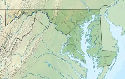
| Location | Garrett County, Maryland |
| Coordinates | 39°30′34″N 79°23′28″W / 39.5095354°N 79.3911531°W |
| Lake type | Reservoir |
| Primary inflows | Deep Creek, Meadow Mountain Run, Cherry Creek, Green Glade Run |
| Primary outflows | Deep Creek |
| Catchment area | 64.7 sq mi (168 km2) |
| Basin countries | United States of America |
| Max. length | 11.25 mi (18.11 km) |
| Max. width | 1.13 mi (1.82 km) |
| Surface area | 3,628 acres (14.68 km2) |
| Max. depth | 75 ft (23 m) |
| Shore length1 | 69 mi (111 km) |
| Surface elevation | 2,461 ft (750 m) |
| Settlements | McHenry, Maryland |
| 1 Shore length is not a well-defined measure. | |
Deep Creek Lake is a man-made reservoir[1] in the U.S. state of Maryland. It covers about 3,900 acres (16 km2) and has 69 miles (111 km) of shoreline.[2] The lake is home to a wide variety of aquatic life, such as freshwater fish and aquatic birds. The Wisp Ski Resort is located nearby.[3]
History
The lake is a result of the Youghiogheny Hydroelectric Company hydroelectric project on Deep Creek in the 1920s. Deep Creek Dam, located about 8 miles (13 km) north of Oakland, Maryland, consists of an earth and rock wall dam across a tributary of the Youghiogheny River. Construction of the dam began in 1923 and was completed in 1925. The hydroelectric plant became operational at 4 p.m. on May 26, 1925.[4] The state of Maryland purchased the lake in 2000 from the Pennsylvania Electric Company, and Deep Creek Lake State Park provides public access to the lake.[5]
Fishing

Climate
Deep Creek Lake has a humid continental climate (Köppen Dfb).
| Climate data for Sines Deep Creek, Maryland, 1991–2020 normals, 1928-2020 extremes: 2040ft (622m) | |||||||||||||
|---|---|---|---|---|---|---|---|---|---|---|---|---|---|
| Month | Jan | Feb | Mar | Apr | May | Jun | Jul | Aug | Sep | Oct | Nov | Dec | Year |
| Record high °F (°C) | 73 (23) |
74 (23) |
82 (28) |
87 (31) |
88 (31) |
93 (34) |
96 (36) |
94 (34) |
95 (35) |
86 (30) |
78 (26) |
75 (24) |
96 (36) |
| Mean maximum °F (°C) | 54.8 (12.7) |
58.4 (14.7) |
70.2 (21.2) |
77.6 (25.3) |
83.7 (28.7) |
85.1 (29.5) |
87.2 (30.7) |
83.1 (28.4) |
83.2 (28.4) |
75.7 (24.3) |
68.6 (20.3) |
58.9 (14.9) |
87.5 (30.8) |
| Mean daily maximum °F (°C) | 34.0 (1.1) |
37.8 (3.2) |
46.9 (8.3) |
59.3 (15.2) |
67.9 (19.9) |
74.9 (23.8) |
79.0 (26.1) |
76.4 (24.7) |
71.5 (21.9) |
61.1 (16.2) |
48.5 (9.2) |
38.2 (3.4) |
58.0 (14.4) |
| Daily mean °F (°C) | 25.3 (−3.7) |
27.7 (−2.4) |
35.7 (2.1) |
46.5 (8.1) |
55.7 (13.2) |
63.3 (17.4) |
67.6 (19.8) |
65.7 (18.7) |
59.8 (15.4) |
49.8 (9.9) |
38.8 (3.8) |
29.6 (−1.3) |
47.1 (8.4) |
| Mean daily minimum °F (°C) | 16.6 (−8.6) |
17.5 (−8.1) |
24.4 (−4.2) |
33.7 (0.9) |
43.5 (6.4) |
51.7 (10.9) |
56.2 (13.4) |
54.9 (12.7) |
48.0 (8.9) |
38.5 (3.6) |
29.0 (−1.7) |
21.0 (−6.1) |
36.2 (2.3) |
| Mean minimum °F (°C) | −3.3 (−19.6) |
−1.1 (−18.4) |
7.7 (−13.5) |
20.0 (−6.7) |
28.9 (−1.7) |
39.3 (4.1) |
47.9 (8.8) |
45.0 (7.2) |
36.4 (2.4) |
27.2 (−2.7) |
15.5 (−9.2) |
8.0 (−13.3) |
−4.2 (−20.1) |
| Record low °F (°C) | −20 (−29) |
−23 (−31) |
−11 (−24) |
11 (−12) |
20 (−7) |
24 (−4) |
35 (2) |
35 (2) |
22 (−6) |
14 (−10) |
−8 (−22) |
−17 (−27) |
−23 (−31) |
| Average precipitation inches (mm) | 4.65 (118) |
4.39 (112) |
4.67 (119) |
4.35 (110) |
4.90 (124) |
5.67 (144) |
5.01 (127) |
4.41 (112) |
3.29 (84) |
3.19 (81) |
3.36 (85) |
4.64 (118) |
52.53 (1,334) |
| Average snowfall inches (cm) | 31.7 (81) |
30.7 (78) |
16.0 (41) |
4.0 (10) |
0.1 (0.25) |
0.0 (0.0) |
0.0 (0.0) |
0.0 (0.0) |
0.0 (0.0) |
2.6 (6.6) |
6.2 (16) |
19.1 (49) |
110.4 (281.85) |
| Source 1: NOAA(Mc Henry 4.8 SSE Precip/Snowfall)[7][8] | |||||||||||||
| Source 2: XMACIS2 (2007-2020 snowfall, records & monthly max/mins)[9] | |||||||||||||
See also
References
- ↑ "Maryland's Lakes and Reservoirs: FAQ". www.mgs.md.gov.
- ↑ Meyer, Eugene L. (2007-09-14). "High-End Rustic on a Plateau in the Alleghenies". The New York Times. Retrieved 2010-05-01.
- ↑ Phillips, John. "Ski & Snowboard America Mid-Atlantic, 2nd". Retrieved 22 December 2010.
{{cite journal}}: Cite journal requires|journal=(help) - ↑ "Yough Dams". History of the Upper Yough. Retrieved 12 July 2014.
- ↑ "The History of Deep Creek". Power Plant Research Program. Maryland Department of Natural Resources. Archived from the original on 14 May 2001. Retrieved 24 February 2013.
- ↑ "Maryland Fish Facts". Maryland Department of Natural Resources. Archived from the original on 4 March 2013. Retrieved 24 February 2013.
- ↑ "Sines Deep Creek, Maryland 1991-2020 Monthly Normals". Retrieved December 13, 2023.
- ↑ "Mc Henry 4.8 SSE, Maryland 1991-2020 Monthly Normals". Retrieved December 13, 2023.
- ↑ "xmACIS". National Oceanic and Atmospheric Administration. Retrieved December 13, 2023.
External links
- Maryland Park Service Deep Creek Lake
- Deep Creek Lake Discovery Center
- Deep Creek Lake Chamber of Commerce
- U.S. Geological Survey Geographic Names Information System: Deep Creek Lake