Highway 88 | ||||
|---|---|---|---|---|
 | ||||
| Route information | ||||
| Maintained by ArDOT | ||||
| Location | ||||
| Country | United States | |||
| State | Arkansas | |||
| Counties | Polk, Montgomery, Garland, Saline, Jefferson | |||
| Highway system | ||||
| ||||

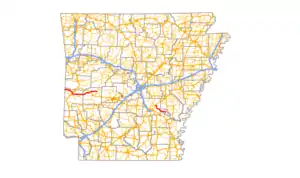
Highway 88 (AR 88, Ark. 88, and Hwy. 88) is a designation for five state highways in Arkansas. All routes are maintained by the Arkansas Department of Transportation (ArDOT).
Oklahoma to Washita
Highway 88 | |
|---|---|
| Location | |
| Length | 60.66 mi[1] (97.62 km) |
| Existed | April 1, 1926[2]–present |
Highway 88 (AR 88, Ark. 88, and Hwy. 88) is a state highway of 60.66 miles (97.62 km) in Western Arkansas. The route begins at the Oklahoma state line at OK-1 and runs west to Highway 27 at Washita. Between the western terminus and Mena, the route passes through the Ouachita Mountains and is designated as part of the Talimena Scenic Drive, an Arkansas Scenic Byway and National Scenic Byway.[3]
Route description
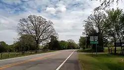
At Mena, it runs along the north direction of U.S. 71 (geographically east) for 2 miles (3.2 km) until U.S. 71 turns back to the north. From there, Highway 88 continues east for 24 miles (39 km) parallelling the Ouachita River and passing through the communities of Ink, Cherry Hill, Pine Ridge and Oden before intersecting U.S. Highway 270 at Pencil Bluff. Highway 88 then continues east another 14 miles (23 km) passing through the community of Sims before ending at Highway 27 at Washita.
Major intersections
Mile markers reset at some concurrencies.
| County | Location | mi | km | Destinations | Notes |
|---|---|---|---|---|---|
| Polk | | 0.00 | 0.00 | Continuation into Oklahoma | |
| Queen Wilhelmina State Park | 5.47 | 8.80 | AR 272 western terminus | ||
| Mena | 17.53– 0.00 | 28.21– 0.00 | |||
| Montgomery | Oden | 26.71 | 42.99 | AR 379 northern terminus | |
| Pencil Bluff | 29.46– 29.81 | 47.41– 47.97 | officially designated exception | ||
| Sims | 33.52 | 53.95 | AR 298 western terminus | ||
| Washita | 43.13 | 69.41 | Eastern terminus | ||
1.000 mi = 1.609 km; 1.000 km = 0.621 mi
| |||||
Hot Springs
Higdon Ferry Road | |
|---|---|
| Location | |
| Length | 2.92 mi[1] (4.70 km) |
Route description

Highway 88 begins and ends at Highway 7 in Hot Springs. It runs about 3 miles and has an intersection with the U.S. 70-270 bypass of Hot Springs along its route.
Major intersections
The entire route is in Hot Springs, Garland County.
| mi[1] | km | Destinations | Notes | ||
|---|---|---|---|---|---|
| 0.00 | 0.00 | Western terminus | |||
| 1.51 | 2.43 | US 70 / US 270 exit 4 | |||
| 2.92 | 4.70 | Eastern terminus | |||
| 1.000 mi = 1.609 km; 1.000 km = 0.621 mi | |||||
Lonsdale
Highway 88 | |
|---|---|
| Location | Strauss Street/Cockrell Avenue in Lonsdale to |
| Length | 1.84 mi[1] (2.96 km) |
Route description
Major intersections
| County | Location | mi[1] | km | Destinations | Notes |
|---|---|---|---|---|---|
| Garland | Lonsdale | 0.00 | 0.00 | Strauss Street/Cockrell Avenue | Western terminus |
| Saline | | 1.84 | 2.96 | Eastern terminus | |
| 1.000 mi = 1.609 km; 1.000 km = 0.621 mi | |||||
Benton
Highway 88 | |
|---|---|
| Location | End state maintenance at Alcoa Road in Benton |
| Length | 2.60 mi[1] (4.18 km) |
Route description
A second segment of Highway 88 begins at an intersection with Highway 35 in Benton, runs for a few blocks on Military Road (a former route of U.S. 67-70 and US 70C/I-30 Business Loop), then runs west approximately 2+1⁄2 miles as Alcoa Road before ending at Benton Parkway.
Major intersections
The entire route is in Benton, Hot Spring County.
| mi[1] | km | Destinations | Notes | ||
|---|---|---|---|---|---|
| 0.00 | 0.00 | Western terminus | |||
| 2.60 | 4.18 | End state maintenance at Alcoa Road | Eastern terminus | ||
| 1.000 mi = 1.609 km; 1.000 km = 0.621 mi | |||||
Altheimer to Reydell
Highway 88 | |
|---|---|
| Location | |
| Length | 23.39 mi[1] (37.64 km) |
Route description
Highway 88 begins at U.S. Highway 79 at Altheimer and runs 24 miles (39 km) south and east passing through the communities of Cornerstone, Sweden, and Swan Lake before ending at Highway 11 at Reydell.
Major intersections
The entire route is in Jefferson County.
| Location | mi[1] | km | Destinations | Notes | |
|---|---|---|---|---|---|
| Altheimer | 0.00 | 0.00 | Western terminus | ||
| Reydell | 23.39 | 37.64 | Eastern terminus, AR 11 southern terminus | ||
| 1.000 mi = 1.609 km; 1.000 km = 0.621 mi | |||||
See also
References
- 1 2 3 4 5 6 7 8 9 System Information and Research Division (2014). "Arkansas Road Log Database". Arkansas State Highway and Transportation Department. Archived from the original (MDB) on August 29, 2017. Retrieved March 27, 2016.
- ↑ Arkansas State Highway Commission (April 1, 1926). Map of the State of Arkansas Showing System of State Highways (TIF) (Map). Little Rock: Arkansas State Highway Commission. Retrieved December 15, 2016.
- ↑ "Talimena Scenic Drive National Scenic Byway". Arkansas State Highway and Transportation Department. Retrieved July 8, 2011.
External links
![]() Media related to Arkansas Highway 88 at Wikimedia Commons
Media related to Arkansas Highway 88 at Wikimedia Commons