Haparanda Municipality
Haparanda kommun | |
|---|---|
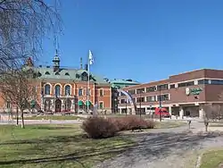 Haparanda Hotel to the left, and the City Hall | |
 Coat of arms | |
 | |
| Coordinates: 65°50′N 24°08′E / 65.833°N 24.133°E | |
| Country | Sweden |
| County | Norrbotten County |
| Seat | Haparanda |
| Area | |
| • Total | 1,868.27 km2 (721.34 sq mi) |
| • Land | 922.76 km2 (356.28 sq mi) |
| • Water | 945.51 km2 (365.06 sq mi) |
| Area as of 1 January 2014. | |
| Population (31 December 2021)[2] | |
| • Total | 9,496 |
| • Density | 5.1/km2 (13/sq mi) |
| Time zone | UTC+1 (CET) |
| • Summer (DST) | UTC+2 (CEST) |
| ISO 3166 code | SE |
| Province | Norrbotten |
| Municipal code | 2583 |
| Website | www.haparanda.se |
Haparanda Municipality (Swedish: Haparanda kommun), (Finnish: Haaparannan kunta) is a municipality in Norrbotten County in northern Sweden. Its seat is located in Haparanda (Finnish: Haaparanta).
In 1967 the "City of Haparanda" was merged with the rural municipalities Karl Gustav and Nedertorneå. Since 1971 Haparanda, like all other municipalities of Sweden, is a municipality of unitary type. However, it prefers to use the title stad ("city") for the whole territory, including the non-urban parts.
Geography
In Sweden, Haparanda Municipality borders Övertorneå Municipality to the north and Kalix Municipality to the west.
Haparanda Municipality is located on the western side of where the Torne River discharges into the Bay of Bothnia. On the other side of the river lies the Finnish town Tornio (Swedish: Torneå). Haparanda and Tornio jointly call themselves "EuroCity".
Although Haparanda has a boat harbor, it is not accessible for larger vessels and is not, as often thought, the Baltic Sea's northernmost port, that honor most probably belonging to Töre further west on the Swedish coast.
The municipality includes the Haparanda archipelago, with 652 islands in the bay of Bothnia, part of the larger Norrbotten archipelago.[3] The Haparanda Archipelago National Park lies within the Haparanda group of islands. It includes the larger islands of Sandskär and Seskar Furö, and some smaller islands and skerries.[4] Some of the other islands in the Haparanda archipelago include Hanhinkari, Kataja, Seskarö, Skomakaren, Stora Hamnskär, Stora Hepokari and Torne-Furö.[5]
Localities
There are five localities (or urban areas) in Haparanda Municipality:[6]
| # | Locality | Population |
|---|---|---|
| 1 | Haparanda | 4,778 |
| 2 | Marielund | 1,865 |
| 3 | Seskarö | 498 |
| 4 | Nikkala | 447 |
| 5 | Karungi | 232 |
The municipal seat in bold
Demographics
This is a demographic table based on Haparanda Municipality's electoral districts in the 2022 Swedish general election sourced from SVT's election platform, in turn taken from SCB official statistics.[7]
Residents include everyone registered as living in the district, regardless of age or citizenship status. Valid voters indicate Swedish citizens above the age of 18 who therefore can vote in general elections. Left vote and right vote indicate the result between the two major blocs in said district in the 2022 general election. Employment indicates the share of people between the ages of 20 and 64 who are working taxpayers. Foreign background is defined as residents either born abroad or with two parents born outside of Sweden. Median income is the received monthly income through either employment, capital gains or social grants for the median adult above 20, also including pensioners in Swedish kronor. The section about college graduates indicates any degree accumulated after high school. Haparanda has a high degree of people of foreign background since records were kept in 2002, mainly a result of cross-border connections with Tornio and Finland.
In total there were 6,198 Swedish citizens of voting age resident in the municipality.[7] 47.7 % voted for the left coalition and 51.3 % for the right coalition.
| Location | Residents | Valid voters | Left vote | Right vote | Employed | SV parents | 1st/2nd gen | Income | College |
|---|---|---|---|---|---|---|---|---|---|
| % | % | % | % | % | % | ||||
| Grankullen | 1,121 | 750 | 44.1 | 54.9 | 78 | 59 | 41 | 26,566 | 30 |
| Haparanda N | 2,365 | 1,459 | 46.0 | 52.3 | 67 | 40 | 60 | 19,798 | 24 |
| Haparanda S | 1,580 | 1,105 | 51.5 | 47.0 | 67 | 40 | 60 | 19,977 | 30 |
| Karungi | 913 | 605 | 41.9 | 57.4 | 74 | 66 | 34 | 20,761 | 22 |
| Marielund | 2,008 | 1,183 | 48.8 | 50.6 | 67 | 40 | 60 | 22,044 | 24 |
| Nikkala | 1,031 | 742 | 48.2 | 51.3 | 78 | 66 | 34 | 24,213 | 26 |
| Seskarö | 467 | 354 | 64.1 | 35.9 | 72 | 69 | 31 | 21,187 | 25 |
| Source: SVT[7] | |||||||||
Politics and government
Distribution of the 35 seats in the municipal council after the 2010 election:
Results of the 2010 Swedish general election in Haparanda:
- Social Democratic Party 60.4%
- Moderate Party 17.2%
- Centre Party 7.3%
- Left Party 4.3%
- Sweden Democrats 3.8%
- Christian Democrats 2.6%
- Green Party 2.3%
- Liberal People's Party 1.5%
Twin towns – sister cities
Haparanda is twinned with:
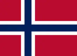 Hammerfest, Norway
 Kovdor, Russia
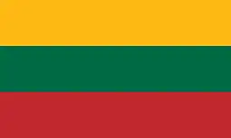 Širvintos, Lithuania
See also
References
- ↑ "Statistiska centralbyrån, Kommunarealer den 1 januari 2014" (in Swedish). Statistics Sweden. 2014-01-01. Archived from the original (Microsoft Excel) on 2016-09-27. Retrieved 2014-04-18.
- ↑ "Folkmängd i riket, län och kommuner 31 december 2021" (in Swedish). Statistics Sweden. February 22, 2022. Retrieved February 22, 2022.
- ↑ "About the Bay of Bothnia". Bottenvikens skärgård. Archived from the original on 2013-10-05. Retrieved 2013-09-30.
- ↑ "Haparanda Skärgård National Park". Swedish Environmental Protection Agency. Retrieved 2013-10-02.
- ↑ "Öar i Haparanda skärgård". bottenviken.se. Retrieved 2013-10-10.
- ↑ Statistics Sweden as of December 31, 2005
- 1 2 3 "Valresultat 2022 för Haparanda i riksdagsvalet" (in Swedish). SVT. 11 September 2022. Retrieved 21 December 2023.
External links
- Haparanda Municipality - Official site
- Haparanda-Tornio - Official tourism site
Places adjacent to Haparanda Municipality | ||||||||||||||||
|---|---|---|---|---|---|---|---|---|---|---|---|---|---|---|---|---|
| ||||||||||||||||
Municipalities and seats of Norrbotten County | ||
|---|---|---|
| Municipalities | ||
| Municipal seats | ||