Elderslea | |
|---|---|
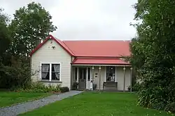 Golder Cottage, a museum of colonial domestic life | |
| Coordinates: 41°07′24″S 175°03′27″E / 41.1232°S 175.0576°E | |
| Country | New Zealand |
| Region | Wellington Region |
| Territorial authority | Upper Hutt |
| Electorates | |
| Government | |
| • Territorial Authority | Upper Hutt City Council |
| • Regional council | Greater Wellington Regional Council |
| • Mayor of Upper Hutt | Wayne Guppy |
| • Remutaka MP | Chris Hipkins |
| • Ikaroa-Rāwhiti MP | Cushla Tangaere-Manuel |
| Area | |
| • Total | 1.40 km2 (0.54 sq mi) |
| Population (June 2023)[2] | |
| • Total | 3,410 |
| • Density | 2,400/km2 (6,300/sq mi) |
Elderslea is a suburb of Upper Hutt located in the lower North Island of New Zealand, near Upper Hutt Central.
Demographics
Elderslea statistical area covers 1.40 km2 (0.54 sq mi).[1] It had an estimated population of 3,410 as of June 2023, with a population density of 2,436 people per km2.
| Year | Pop. | ±% p.a. |
|---|---|---|
| 2006 | 3,183 | — |
| 2013 | 3,225 | +0.19% |
| 2018 | 3,429 | +1.23% |
| Source: [3] | ||
Elderslea had a population of 3,429 at the 2018 New Zealand census, an increase of 204 people (6.3%) since the 2013 census, and an increase of 246 people (7.7%) since the 2006 census. There were 1,230 households, comprising 1,656 males and 1,773 females, giving a sex ratio of 0.93 males per female. The median age was 40.7 years (compared with 37.4 years nationally), with 663 people (19.3%) aged under 15 years, 612 (17.8%) aged 15 to 29, 1,455 (42.4%) aged 30 to 64, and 702 (20.5%) aged 65 or older.
Ethnicities were 76.6% European/Pākehā, 18.1% Māori, 6.8% Pasifika, 10.5% Asian, and 3.4% other ethnicities. People may identify with more than one ethnicity.
The percentage of people born overseas was 20.7, compared with 27.1% nationally.
Although some people chose not to answer the census's question about religious affiliation, 44.4% had no religion, 42.3% were Christian, 1.0% had Māori religious beliefs, 1.8% were Hindu, 0.3% were Muslim, 1.2% were Buddhist and 2.1% had other religions.
Of those at least 15 years old, 405 (14.6%) people had a bachelor's or higher degree, and 600 (21.7%) people had no formal qualifications. The median income was $27,800, compared with $31,800 nationally. 384 people (13.9%) earned over $70,000 compared to 17.2% nationally. The employment status of those at least 15 was that 1,290 (46.6%) people were employed full-time, 297 (10.7%) were part-time, and 132 (4.8%) were unemployed.[3]
Education
Fraser Crescent School is a co-educational state primary school for Year 1 to 6 students,[4][5] with a roll of 224 as of April 2023.[6]
Maidstone Intermediate is a co-educational state intermediate school for Year 7 to Year 8 students,[7] with a roll of 493.[8]
References
- 1 2 "ArcGIS Web Application". statsnz.maps.arcgis.com. Retrieved 3 June 2021.
- ↑ "Population estimate tables - NZ.Stat". Statistics New Zealand. Retrieved 25 October 2023.
- 1 2 "Statistical area 1 dataset for 2018 Census". Statistics New Zealand. March 2020. Elderslea (241900). 2018 Census place summary: Elderslea
- ↑ "Fraser Crescent School Official School Website". frasercres.school.nz.
- ↑ "Fraser Crescent School Education Review Office Report". ero.govt.nz. Education Review Office.
- ↑ "Fraser Crescent School Ministry of Education School Profile". educationcounts.govt.nz. Ministry of Education.
- ↑ "Maidstone Intermediate Education Review Office Report". ero.govt.nz. Education Review Office.
- ↑ "Maidstone Intermediate Ministry of Education School Profile". educationcounts.govt.nz. Ministry of Education.