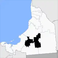
Escárcega | |
|---|---|
 | |
| Country | Mexico |
| State | Campeche |
| Municipal seat | Escárcega |
| Government | |
| • Municipal president | Aureliano Quirarte Rodríguez (2006-09) |
| Area | |
| • Total | 4,733.87 km2 (1,827.76 sq mi) |
| Elevation | 60 m (200 ft) |
| Population (2015) | |
| • Total | 58,553 |
| • Density | 12/km2 (32/sq mi) |
| municipality | |
| Time zone | UTC−6 (CST) |
| • Summer (DST) | UTC−5 (CDT) |
| Created | 1 January 1991 |
| Website | www.escarcega.gob.mx |
Escárcega is one of the 13 municipalities in the Mexican state of Campeche. The municipal seat, and largest settlement, is the city of Escárcega.
Geography
The municipality of Escárcega borders to the north with the municipality of Champotón, to the east with the municipality of Calakmul, to the south with the municipality of Candelaria, and to the west with the municipality of Carmen.
It covers 4,569.64 km², accounting for 8.0% of the state's total surface area.
History
The municipality was created on 1 January 1991. It took its name from its municipal seat, which was in turn named for Tlaxcalan railwayman Francisco Escárcega, who built the Ferrocarril del Sureste that runs from Coatzacoalcos, Ver., to Campeche, Camp.
Demographics
As of 2010, the municipality had a total population of 54,184.[1]
As of 2010, the city of Escárcega had a population of 29,477.[1] Other than the city of Escárcega, the municipality had 539 localities, the largest of which (with 2010 populations in parentheses) were: División del Norte (3,259), classified as urban, and La Libertad (1,462), Matamoros (1,453), Haro (1,092), Don Samuel (1,081), and Altamira de Zináparo (1,040), classified as rural.[1]
Transportation
Escárcega territory is a major hub of both roads and railways with these being the main driver of development in the region. Before their existence Escárcega was virtually depopulated.
Roads
The main roads connecting the municipality of Escárcega are Federal Highway 186 and Federal Highway 254. The Federal Highway 186 is the primary means of transportation and economic activity in the territory. The Federal Highway 254 is a small road that connects to 186.[2]
Railways
The introduction of the railroad in the mid-1930s was the real engine of development in the state of Campeche where the present day municipality of Escárcega lies. The railway connected the Yucatán Peninsula with the rest of the country for the first time in the Mexico's history. The railway passes through the municipality of Escárcega southwest to northeast with the main station in the municipalities seat, Escárcega. To the north it connects with the city of Campeche and then Mérida, and southward with Tenosique, Tabasco. The total length of railways in the municipality is 6769 km.[2]
Airports
There are three airports within the municipality that serve the public which are located in Escárcega, Don Samuel, and Pancho Villa.[2]
References
- 1 2 3 "Escárcega". Catálogo de Localidades. Secretaría de Desarrollo Social (SEDESOL). Retrieved 23 April 2014.
- 1 2 3 "Mapa con Principales Carreteras". Instituto Nacional de Estadística, Geografía e Informática. Archived from the original on 6 March 2012. Retrieved 15 July 2008.
External links
- Ayuntamiento de Escárcega Official website (in Spanish)
- Link to tables of population data from Census of 2005 INEGI: Instituto Nacional de Estadística, Geografía e Informática
- "Campeche - Escárcega". Archived from the original on 2012-04-03. Retrieved 2008-02-29.
- "Escarcega hoteles restaurantes imagenes - Escarcega". Archived from the original on 2013-06-20. Retrieved 2013-03-05.
