Hawthorne, Florida | |
|---|---|
 Location in Alachua County and the state of Florida | |
| Coordinates: 29°35′17″N 82°5′2″W / 29.58806°N 82.08389°W[1] | |
| Country | United States |
| State | Florida |
| County | Alachua |
| Incorporated (city) | 1881 |
| Government | |
| • Mayor | Jacquelyn Randall |
| • Vice mayor | Patricia Bouie-Hutchinson |
| • Commissioner | Tommie Howard Raymond Cue Randy Martin |
| Area | |
| • Total | 7.64 sq mi (19.79 km2) |
| • Land | 7.38 sq mi (19.11 km2) |
| • Water | 0.26 sq mi (0.68 km2) |
| Elevation | 148 ft (45 m) |
| Population (2020) | |
| • Total | 1,478 |
| • Density | 200.27/sq mi (77.33/km2) |
| Time zone | UTC-5 (Eastern (EST)) |
| • Summer (DST) | UTC-4 (EDT) |
| ZIP code | 32640 |
| Area code | 352 |
| FIPS code | 12-29275[1] |
| GNIS feature ID | 0283829[4] |
| Website | www |
Hawthorne (/ˈhɔːθoʊrn/ ⓘ) is a city in Alachua County, Florida, United States, incorporated in 1881. Indigenous peoples of the Americas had been living in the area since around 100 CE; Hawthorne grew around their trading trails. Throughout its history, Hawthorne has been known for its agriculture, railroad, and rural lifestyle. Hawthorne's population was 1,478 at the 2020 census, with an area of 7.38 sq mi (19.1 km2).
History
People have been living in the Hawthorne area since the mid-Woodland period; a Cades Pond culture (100–600 CE) mound is near the city,[5] and an Alachua culture (600–1700 CE) campsite was found in Hawthorne with aboriginal ceramics and lithics.[6][7] Timucua-speaking natives were living in North Florida when the Spanish arrived during the 16th century. Natives in Alachua County were allied with Chief Potano, and those in Palatka were allied with Chief Utina.[8] In 1774, William Bartram traveled between western Alachua County and the Palatka area on what he called an "old Spanish highway",[9] an "old Indian and trading trail" which passed through the Hawthorne area.[10][11][12] Hawthorne's history is tied to its crossroads.[13]
A road between Micanopy and Palatka via the Hawthorne area appears on an 1837 map.[14] During the 1840s, a mill was constructed on Little Orange Creek, 1.5 miles (2.4 km) east of the center of present-day Hawthorne. The Pleasant Grove Baptist Church was founded at this time, and a post office opened at the mill in 1854. In 1869, the area's first school opened in a log cabin.[15]
Phosphate was discovered near Hawthorne during the late 1870s. Near the same time, the first subdivision, the Town of Hawthorn, was platted. The area had been previously known as Jamestown—named after James M. Hawthorn.[15][16][17] A second subdivision, Waits Crossing, was platted in 1881. The subdivisions provided north–south and east–west rights-of-way, which brought rail service.[18] Track was first laid by the Peninsula Railroad in Hawthorne in 1879 for a north–south line intended to connect Waldo and Ocala. Near the same time, track laid by the Florida Southern Railroad reached Hawthorne; its east–west line was intended to connect Palatka and Gainesville.[19][20] Each railroad company had a depot in the Hawthorne area, about a half-mile apart.[21] A Hawthorn post office was established in 1880, and its spelling was changed to Hawthorne in 1950.[22]
In 1881, 36 years after Florida became a state, the state legislature created the municipal corporation of Hawthorne.[18] Florida Southern began selling land granted to it by the state almost a decade after the railroads were built, including land in Hawthorne described as "in the heart of a famous vegetable region ... large public school, churches, stores, hotels, three cotton gins, wagon repair shop."[23] At this time, Hawthorne was known for its hunting and fishing and "Northern sportsmen frequented the area to enjoy" it. Sportsmen could stay at William Shepard Moore's hotel; he served breakfast early and had hunting dogs, guides, and horses available.[24]
During the 1880s many orange groves were planted in the Hawthorne area,[24] but after the 1894 Great Freeze ruined citrus trees, growers switched to vegetables; the area became known for Sea Island cotton (Pima cotton) around the turn of the 20th century although it had been grown there since at least the early 1880s.[25][26] The boll weevil halted the cotton trade, however, and Hawthorne diversified into brickmaking, other agriculture, turpentine production, and railroad work.[27] Because two rail lines crossed in the city, it became a transfer point; there was no passenger station, however, and travelers had to walk (or ride) to the connecting line's depot. The Florida state railroad commission declared that the depots were inadequate to accommodate the "traveling public", and required the rail companies to build a segregated union passenger station in Hawthorne by November 1912.[28] Hawthorne was a bustling community in 1913 with a cotton gin, a bank, four general stores, a drug store, three hotels, and two furniture stores.[29]
The city experienced a boom during the 1920s; by late in the decade, Hawthorne had a bank, high school, ice and electric plants, a Western Union, a Railway Express Agency, and a telephone exchange.[30] Although the city suffered during the Great Depression, daily rail service continued; Highway 20 was paved, and a bridge was built over the railroad tracks. The area remained an agricultural center.[31]
The original city hall burned during the mid-to-late 1930s and was replaced by a "white stucco building with Mediterranean influence",[32] which was Hawthorne's city hall until 2018.[33] That year, the city hall moved down the street to an old bank building on the corner of County Road 2082, and the old city-hall building began use as a community center.[34][35]
During the 1940s, agriculture declined because the land had not been replenished.[36] The pulpwood industry began when National Container (a box company later purchased by Owens-Illinois)[37] bought 15,000 acres (6,100 ha) in the area. A state forest was created south of Hawthorne with 40,000 acres (16,000 ha) of purchased land.[38] While there was not much growth after World War II, Hawthorne was still a center for hunting and fishing.[29] Little growth occurred in the 1950s and 1960s; Hawthorne was known for its lima beans, and more farmland was sold to lumber companies. Trees were still tapped for turpentine before that industry ended in the late 1950s. US 301, built during the early 1960s, bypassed downtown Hawthorne to reduce driving times.[36]
Growth revived somewhat during the 1970s. As automobiles became the dominant means of transportation, passenger trains and buses stopped serving the city. Many residents began commuting to Gainesville to work after local industries declined. The area's rural lifestyle became appreciated during the 1980s, although local jobs still existed at sand mines, chicken ranches, and plywood mills.[39] Since the 1980s, Hawthorne has experienced little population growth.[lower-alpha 1]
The city of Hawthorne annexed approximately 1,300 acres owned by Plum Creek Land Company in 2015.[40]
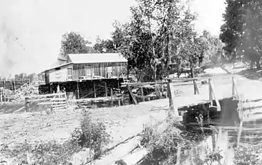 Morrison's Mill, c. 1850
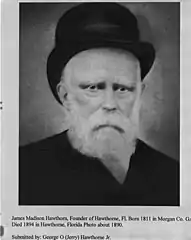 James M. Hawthorn, c. 1890
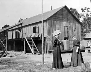 Cotton gin, c. 1900
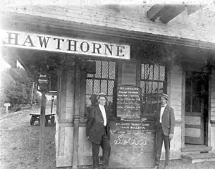 Railroad station, 1914
%252C_front.jpg.webp) Historical marker, front
Historical marker, front.jpg.webp) Historical marker, reverse
Historical marker, reverse Old city hall, c. 2008
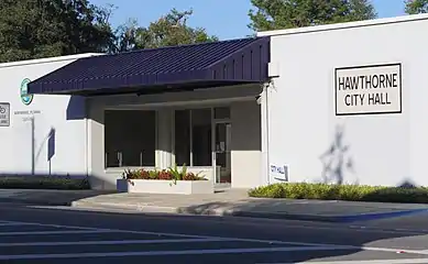 New city hall, 2018
Geography
Hawthorne is on the eastern boundary of Alachua County, and a portion of the city borders the Alachua–Putnam county line.[41] It is 17 miles (27 km) east of Gainesville, the largest city in the county.[42] According to the United States Census Bureau, the city has a total area of 7.06 sq mi (18.3 km2); 6.802 sq mi (17.62 km2) is land, and 0.258 sq mi (0.67 km2) is water.[1]
Demographics
| Census | Pop. | Note | %± |
|---|---|---|---|
| 1900 | 296 | — | |
| 1910 | 324 | 9.5% | |
| 1920 | 543 | 67.6% | |
| 1930 | 600 | 10.5% | |
| 1940 | 741 | 23.5% | |
| 1950 | 1,058 | 42.8% | |
| 1960 | 1,167 | 10.3% | |
| 1970 | 1,126 | −3.5% | |
| 1980 | 1,303 | 15.7% | |
| 1990 | 1,305 | 0.2% | |
| 2000 | 1,415 | 8.4% | |
| 2010 | 1,417 | 0.1% | |
| 2020 | 1,478 | 4.3% | |
| U.S. Decennial Census[43] | |||
| Hawthorne Comparative Demographics 2013–2017 American Community Survey 5-Year Estimates[44] | ||||
|---|---|---|---|---|
| Hawthorne | Alachua County | Florida | United States | |
| Total population | 1,862 | 259,865 | 20,278,447 | 321,004,407 |
| Owner-occupied housing, median value | $127,900 | $167,000 | $178,700 | $193,500 |
| Median household income | $37,500 | $45,478 | $50,883 | $57,652 |
| Individuals below poverty level | 29.0% | 23.3% | 15.5% | 14.6% |
| High school degree or higher | 82.0% | 92.1% | 87.6% | 87.3% |
| Bachelor's degree or higher | 18.9% | 41.4% | 28.5% | 30.9% |
| Foreign born | 2.26% | 9.97% | 20.25% | 13.14% |
| White | 48.82% | 69.54% | 75.67% | 73.01% |
| Black | 47.69% | 20.16% | 16.13% | 12.65% |
| Hispanic (any race) | 2.79% | 9.26% | 24.73% | 17.6% |
| Asian | 0.21% | 5.88% | 2.68% | 5.35% |
| Other | 0.21% | 0.88% | 2.64% | 4.71% |
| Two or more races | 3.06% | 3.16% | 2.54% | 3.14% |
| Veterans | 6.39% | 5.95% | 7.17% | 5.9% |
The 2020 census listed the population of Hawthorne as 1,478.[45] The 2010 census listed 1,417 people, 561 households, and 357 families residing in the city.[46] Hawthorne's population density was 295.2 inhabitants per square mile (114.0/km2). There were 681 housing units, with an average density of 141.9 per square mile (54.8/km2). The city's racial makeup was 52.4 percent white, 45.3 percent black or African American, 0.1 percent native American, 0.3 percent Asian, 0.5 percent other races, and 1.5 percent two (or more) races. Hispanics or Latinos of any race were two percent of the population.
Of the 561 households, 31.6 percent had children under age 18 living with them; 38.3 percent were married couples living together, 21.0 percent had a female householder with no husband present, and 36.4 percent were non-families. Individuals made up 31.4 percent of all households, 12.0 percent of whom were age 65 or older. The average household size was 2.534, and the average family size was 3.15.
By age, 23.2 percent were under age 18; 2.4 percent were 18 to 21, 52.9 percent were 21 to 62, and 20.1 percent were age 62 or older; the median age was 41.5 years. For every 100 females, there were 86.2 males; for every 100 females over 18, there were 86.6 males.
According to the Census Bureau,[47] median household income in the city was $37,500 and median family income was $46,875. Hawthorne's per capita income was $14,353. About 25.5 percent of families and 29.0 percent of the population were below the poverty line, including 34.8 percent of those under age 18 and 16.6 percent of those aged 65 or over.
Government
Hawthorne is chartered as a commission–manager[48] form of government. The charter officers are the city commission, with five commissioners, a mayor, and a vice-mayor. A city manager is responsible to the commission for the administration of all city affairs.[49]
The mayor of Hawthorne is Jacquelyn Randall.[50]
Attractions
Hawthorne obtained 3,000 acres (1,200 ha) surrounding Little Orange Creek (where a historic mill operated) in 2011.[51] The Little Orange Creek Nature Park opened in 2017.[52] Managed by the city, it is divided into two sections. About 65 acres (26 ha) south of State Road 20 are the nature park, and include parking and an environmental-education and event center. North of State Road 20 are 2,800 acres (1,100 ha) which are "preserved as a conservation area for local plants and wildlife". The preserve has public trails for hiking, bicycling, and horseback riding.[51]
The city also owns and maintains Lindsey Phillips Park, off US Highway 301. The park (on Johnson Lake) has a boat ramp, fishing pier, playground, and picnic facilities.[53]
Several conservation areas are south and west of Hawthorne. Immediately adjacent to the city is the over-11,000-acre (4,500 ha) Lochloosa Wildlife Management Area. Its Cross Creek Trail is part of the Great Florida Birding and Wildlife Trail.[54] Lochloosa Wildlife Management Area provides opportunities for hiking, bicycling, horseback riding, hunting, fishing, canoeing, and boating.[55]
Marjorie Kinnan Rawlings Historic State Park, about fourteen miles southwest of Hawthorne, maintains the "authentic Florida cracker homestead" where Rawlings lived and wrote her Pulitzer Prize-winning books.[56] Although Rawlings did not live in Hawthorne, she used the Hawthorne post office and received mail addressed to "Hawthorn".[57]
Sports
The city owns and maintains Hawthorne Athletic Park, which has four dual-use baseball-softball fields, a multi-purpose field, a playground, concession stand, and picnic facility.[53] A non-profit organization, Hawthorne Youth Sports, offers a variety of sports for children in the area: baseball, softball, t-ball, tackle football, soccer, basketball, and cheerleading.[58] The Hawthorne Hornets football team, coached by former NFL player Cornelius Ingram, plays at the Hawthorne High School football stadium.[59] In 2018, the city opened a wellness center adjacent to Hawthorne Athletic Park; most of the gym members are senior citizens.[60][61]
Infrastructure
Transportation
.jpg.webp)
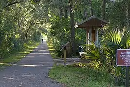
The city sits at the intersection of US Highway 301 and Florida State Road 20.[62]
CSX Transportation owns the north–south rail line which runs through Hawthorne, and operates a station.[63] The line, part of the Wildwood Subdivision, is used for freight. Its Edgar spur runs from Hawthorne to Edgar (near Interlachen),[64] and the 1912 railroad station is used as a business.[65]
The Gainesville-Hawthorne State Trail connects Gainesville to Hawthorne with a sixteen-mile, paved trail.[66] The trail runs through conservation areas in Alachua County that features wetlands, upland hammocks, and pine flatwoods,[29] and can be used for walking, cycling, and (in parts) horseback riding.[67] It was created through the Rails-to-Trails program, which converted the abandoned railroad between Hawthorne and Gainesville to a recreational trail.[68]
Utilities
The Department of Public Works provides solid-waste pickup (including recyclable items), potable water, and a sewer system with wastewater services.[69] Electrical power is provided by Florida Power & Light and the Clay Electric Cooperative.[70]
Health care
Medical services are provided by Azalea Health, which operates a clinic in the city.[71] Fifteen hospitals are within 30 miles (48 km) of Hawthorne. The closest are in Gainesville: Shands Hospital, North Florida/South Georgia Veteran Affairs Health Care System, and the North Florida Regional Medical Center. To the east, Putnam Community Medical Center is available for Hawthorne residents who are closer to Palatka. Florida Hospital Ocala and Ocala Regional Medical Center are in Ocala, south of Hawthorne.[72]
In August 2018,[73] Shands Hospital was the only Level I trauma center in Alachua and its eight adjacent counties. Ocala Regional Medical Center in Marion County and Orange Park Medical Center in Clay County offer Level II trauma services.[74]
Emergency services
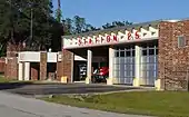
Law enforcement in Hawthorne is provided by the Alachua County Sheriff's Office,[75] and emergency services are provided by Alachua County Fire Rescue.[76] In 2015, Alachua County Fire Rescue Station 62 moved into a renovated station in Hawthorne. The station (number 25) houses a fire engine, rescue ambulance, brush truck, and tanker.[76]
Education
Hawthorne is served by the Alachua County Public Schools, which operates Shell Elementary School and Hawthorne Middle/High School.[77][78] The Alachua County Library District has a branch library in the city.[79] The elementary school was named after Chester Shell, who spearheaded a campaign to open a school for black children in Hawthorne. The school for black students opened in 1922 as Hawthorne High School. Schools at that location were known as Hawthorne High School, Shell High School, Shell Middle School, and Shell Elementary School.[80]
Media
Television stations available over the air in Hawthorne are WUFT PBS, WOGX Fox, WCJB-TV ABC, WGFL CBS, and WYME-CD MeTV.[81] There are 22 AM and FM radio stations within a 25-mile (40 km) radius of the city.[82] The Gainesville Sun, The Independent Florida Alligator, and Alachua County Today are local newspapers.[83]
Notable people
- Bo Diddley,[84][85] musician
- James B. Edwards,[86] Governor of South Carolina
- Cornelius Ingram,[87] National Football League player
- D. R. "Billy" Matthews,[88] Congressman from North Florida (1953–1965)
Notes
- ↑ See historical population table in demographics section.
References
- 1 2 3 US Gazetteer files 2018.
- ↑ "Mayor & City Commission | Hawthorne FL". www.cityofhawthorne.net.
- ↑ "2020 U.S. Gazetteer Files". United States Census Bureau. Retrieved October 31, 2021.
- ↑ Geonames 2008.
- ↑ Hemmings 1978, pp. 142–143.
- ↑ Historic Hawthorne 1996, p. 22.
- ↑ Florida Master File 1990, AL02562.
- ↑ Milanich 1996, pp. 52–53.
- ↑ Bartram 2012.
- ↑ Historical Marker Database 2017.
- ↑ Historical Marker.
- ↑ Historical Marker Back.
- ↑ Historic Hawthorne 1996, p. 26.
- ↑ Lee 1837.
- 1 2 Historic Hawthorne 1996, p. 23.
- ↑ Census Reports 1884, p. 13.
- ↑ Florida Fact 1992.
- 1 2 Historic Hawthorne 1996, p. 24.
- ↑ Historic Hawthorne 1996, p. 32.
- ↑ Census Reports 1884, p. 9.
- ↑ Historic Hawthorne 1996, p. 41.
- ↑ Postal History.
- ↑ Matthews 1888.
- 1 2 Historic Alachua County, p. 163.
- ↑ Historic Hawthorne 1996, p. 25.
- ↑ Eden of the South.
- ↑ Historic Hawthorne 1996, p. 45.
- ↑ Railroad Commission Report 1908, pp. 58–59.
- 1 2 3 Historic Alachua County, p. 164.
- ↑ Historic Hawthorne 1996, p. 48.
- ↑ Historic Hawthorne 1996, p. 51.
- ↑ Historic Hawthorne 1996, pp. 50, 88.
- ↑ Matheson Museum Photograph Collection.
- ↑ WCJB ABC20 CH 2018.
- ↑ City of Hawthorne Community Center.
- 1 2 Historic Hawthorne 1996, p. 53.
- ↑ Florida Memory 1950.
- ↑ Historic Hawthorne 1996, p. 52.
- ↑ Historic Hawthorne 1996, pp. 53, 55.
- ↑ WUFT, October 17, 2019.
- ↑ Alachua County Property Appraiser 2018.
- ↑ Dooley, Pat (February 20, 2004). "Hawthorne completes its field of dreams". Gainesville Sun. Retrieved September 13, 2019.
- ↑ Decennial Census.
- ↑ Census: Fact Finder, 2013–2017 American Community Survey 5-Year Estimates.
- ↑ Census 2020 Redistricting.
- ↑ Census: Fact Finder, 2010 Demographic Profile.
- ↑ Census: Fact Finder, 2012-2016 American Community Survey 5-Year Estimates.
- ↑ Commission-Manager Govt.
- ↑ Charter.
- ↑ Florida Mayors 2021.
- 1 2 Friends of Little Orange Creek.
- ↑ Sargent 2017.
- 1 2 City of Hawthorne Parks.
- ↑ Florida Birding Trail.
- ↑ Lochloosa Wildlife Management Area.
- ↑ Rawlings State Park.
- ↑ Kisling 2014.
- ↑ Hawthorne Youth Sports.
- ↑ LaPeer 2018.
- ↑ WCJB ABC20 WC 2018.
- ↑ WUFT, February 2, 2019.
- ↑ FL DOT.
- ↑ CSX Map.
- ↑ CSX Timetable.
- ↑ Surviving Florida Train Station.
- ↑ Cunningham 2018.
- ↑ Florida State Parks.
- ↑ Rails-to-Trails.
- ↑ City of Hawthorne DPW.
- ↑ Public Power.
- ↑ Azalea Health.
- ↑ Hawthorne Hospitals.
- ↑ Florida Trauma Centers.
- ↑ Trauma System Florida.
- ↑ ACSO.
- 1 2 ACFR stations.
- ↑ Chester Shell.
- ↑ Alachua County Public Schools.
- ↑ Alachua County Library District, Locations.
- ↑ Longstreth, p. 14.
- ↑ TV stations.
- ↑ Radio stations.
- ↑ Newspapers.
- ↑ Ramakers 2008.
- ↑ Capace 2001, p. 173.
- ↑ Capace 2000, p. 149.
- ↑ Savage 2014.
- ↑ Van Ness 2011.
Sources
- "2018 U.S. Gazetteer Files". United States Census Bureau. Retrieved November 2, 2018.
- "Alachua County". Jim Forte Postal History. Retrieved November 2, 2018.
- "Alachua County Fire Rescue Department History". www.alachuacounty.us. Retrieved November 15, 2018.
- "Alachua County Sheriff's Office". www.alachuasheriff.org. Retrieved November 15, 2018.
- "American FactFinder". United States Census Bureau. Archived from the original on February 14, 2020. Retrieved November 2, 2018.
- Annual Report of the Railroad Commission of the State of Florida, Volumes 11-17. The Commission. Railroad Commission of the State of Florida. 1908.
- Bartram, William (April 30, 2012). Travels of William Bartram. Courier Corporation. ISBN 9780486138664.
- "Hawthorne appoints Jacquelyn Randall as mayor". wcjb.com. Retrieved August 16, 2021.
- Capace, Nancy (2001). Encyclopedia of Mississippi. Somerset Publishers, Inc. ISBN 9780403096039.
- Capace, Nancy (2000). Encyclopedia of South Carolina Volume 1 of Encyclopedia of the United States. Somerset Publishers, Inc. ISBN 9780403093472.
- "Census of Population and Housing". Census.gov. Retrieved June 4, 2015.
- "2020 Census (P.L. 94-171) Redistricting Data Summary Files". Census.gov. Retrieved August 16, 2020.
- Census Reports Tenth Census: Report on cotton production in the United States; and also embracing agricultural and physico-geographical descriptions of the several cotton states and of California Volume 6 of Census Reports Tenth Census, United States. Census Office. United States. Census Office. U.S. Government Printing Office. 1884. p. 13.
- "Chester Shell Elementary School". Retrieved December 11, 2018.
- "City Hall, Hawthorne, Fla". ufdc.ufl.edu. Retrieved October 30, 2018.
- "The Commission-Manager Form of Government" (PDF). Retrieved December 11, 2018.
- "Community Center Hawthorne FL". www.cityofhawthorne.net. Retrieved July 25, 2019.
- "CSX Printable System Map". CSX Corporation. Retrieved November 8, 2018.
- "DTV Reception Maps". Federal Communications Commission. Retrieved December 1, 2018. for zip code 32640
- Cunningham, Ron. "Exploring Florida on two wheels". Gainesville Sun. Retrieved October 30, 2018.
- "Dataset Alachua County Property Appraiser GIS". data-acpa.opendata.arcgis.com. Retrieved October 30, 2018.
- Downing, R.R. (January 1, 2005). "CSX Transportation Jacksonville Division Timetable No. 4" (PDF). Multimodalways Project. Retrieved November 8, 2018.
- "Elected Officials: Municipalities". www.votealachua.com. October 29, 2018. Retrieved October 29, 2018.
- "Florida Electric Industry Maps" (PDF). Florida Municipal Electric Association. 2010. Archived from the original (PDF) on October 31, 2018. Retrieved October 30, 2018.
- "Florida Fact". news.google.com. Ocala Star-Banner. Retrieved October 29, 2018 – via Google News Archive Search.
- "Florida Newspapers - Florida Newspaper List". www.usnpl.com. Retrieved December 1, 2018.
- Florida, State Library and Archives of. "View of the National Container Corporation mill near the railroad tracks in Jacksonville, Florida". Florida Memory. Retrieved November 3, 2018.
- "Florida Trauma Centers" (PDF). Retrieved December 11, 2018.
- Fuller, Josephine (February 14, 2019). "Seniors At Hawthorne Wellness Center Keep Their Minds And Bodies Healthy". WUFT News. Retrieved February 22, 2019.
- "Gainesville-Hawthorne State Park Trail Florida Trails TrailLink.com". www.traillink.com. Retrieved November 3, 2018.
- "Gainesville-Hawthorne State Trail". Florida State Parks. Retrieved October 30, 2018.
- Grady-Weil, Julia (October 17, 2019). "Hawthorne Climbs Back With $27 Million Makeover". WUFT. Retrieved September 10, 2020.
- "A Guide to the Donald Ray (Billy) Matthews Papers". www.library.ufl.edu. Retrieved October 29, 2018.
- "Hawthorne Alachua County Library District". www.aclib.us. Retrieved November 9, 2018.
- "Hawthorne - Azalea Health". azahealth.org. Retrieved October 31, 2018.
- areavibes. "Hawthorne, FL Crime Rates & Crime Map". AreaVibes. Retrieved December 1, 2018.
- Hawthorne, Florida, Marker Back (plaque outside First Baptist Church). Hawthorne, Florida: Alachua County Historical Commission in Cooperation with Department of State. 1973. Retrieved November 1, 2018.
- Hawthorne, Florida, Marker Front (plaque outside First Baptist Church). Hawthorne, Florida: Alachua County Historical Commission in Cooperation with Department of State. 1973. Retrieved November 1, 2018.
- "Hawthorne Historical Marker". July 23, 2017. Retrieved October 31, 2018.
- Hawthorne R & T (textual record), Tallahassee, Florida, USA: Florida Master Site File, Florida Department of State, Division of Historical Resource, Bureau of Historic Preservation, November 1990, AL02562
- Historic Hawthorne Florida Survey and Plan (Report). University of Florida. July 1996.
- Hemmings, E. Thomas (December 1978). "Cades Pond Subsistence, Settlement, and Ceremonialism". The Florida Anthropologist. 31 (4). Retrieved November 2, 2018.
- "History". Friends of Little Orange Creek. October 1, 2012. Retrieved November 7, 2018.
- "Home". hys.youthsports.tripod.com. Retrieved November 7, 2018.
- "Hospitals in hawthorne, florida - US Hospital Finder". www.ushospitalfinder.com. Retrieved November 30, 2018.
- Kimble, Josh. "Jacquelyn Randall wins election for Hawthorne City Commission seat". www.wcjb.com. Retrieved July 25, 2019.
- Kisling, Vernon N. Jr. (January 2014). "Marjorie Kinnan Rawlings and the Cross Creek Mail" (PDF). Florida Postal History Society Journal. 21 (1): 1, 3–5.
- LaPeer, Scott. "HIGH SCHOOL FOOTBALL SPOTLIGHT: Hawthorne Hornets". Gainesville Sun. Retrieved November 7, 2018.
- Lee, Williams J. (1837). Map of Florida, 1837 (Map). Retrieved November 2, 2018 – via RICHES of Central Florida.
- "Lochloosa Wildlife Conservation Area GFBWT". floridabirdingtrail.com. Retrieved November 7, 2018.
- "Lochloosa Wildlife Management Area". myfwc.com. Retrieved November 7, 2018.
- Longstreth, James W. (1976). Alachua County Schools and How They Got Their Names. Alachua County School Board.
- "Marjorie Kinnan Rawlings Historic State Park". Florida State Parks. Retrieved November 7, 2018.
- Matthew, Northrup & Co. (1888). Map of Florida Showing the Land Grant of the Florida Southern Railway (Map). Retrieved November 2, 2018 – via RICHES of Central Florida.
- Milanich, Jerald T. (1996). Timucua. VNR AG. ISBN 9781557864888.
- "Municode Library". library.municode.com. Retrieved November 7, 2018.
- "Parks". www.cityofhawthorne.net. Retrieved May 16, 2019.
- "Public Works". www.cityofhawthorne.net. Retrieved May 16, 2019.
- Pickard, John B. (2001). Historic Alachua County and old Gainesville : a tour guide to the past. Gainesville, FL: Alachua Press. ISBN 978-0967278865. OCLC 50765140.
- "Radio Stations in 32640". radio-locator.com. Retrieved December 1, 2018.
- Ramakers, Johan (October 10, 2016). "Bo Diddley 6/2008 - Rock and Roll Paradise". Rock and Roll Paradise. Retrieved October 29, 2018.
- Sargent, Alex. "Once the hub of Hawthorne, Little Orange Creek prepares to shine". Gainesville Sun. Retrieved November 7, 2018.
- Savage, Larry. "Former Gator Ingram named head coach at alma mater". Gainesville Sun. Retrieved October 29, 2018.
- "Schools & Centers Directory / All Schools & Centers". www.sbac.edu. Retrieved November 2, 2018.
- "Stations". www.alachuacounty.us. Retrieved November 15, 2018.
- "Straight-Line Diagrams Online GIS Web Application". www2.dot.state.fl.us. Archived from the original on March 6, 2014. Retrieved October 30, 2018.
- "Surviving Florida Railroad Stations" (PDF). American-Rails.com. Retrieved November 8, 2018.
- "Trauma System Florida Department of Health". www.floridahealth.gov. Retrieved November 30, 2018.
- "US Board on Geographic Names". United States Geological Survey. October 25, 2007. Retrieved January 31, 2008.
- WCJB. "Hawthorne opens new downtown city hall". Retrieved October 30, 2018.
- WCJB. "NCFL city welcomes wellness center". Retrieved November 7, 2018.
- Webber, Carl (1883). The Eden of the South (Electronic reproduction). New York: Leve & Alden. pp. 60–61. LCCN 01021712. Retrieved December 12, 2018.
