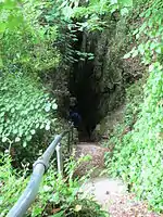

The Devil's Chimney was a scenic rock cleft with steps that descended into the Bonchurch Landslips between Bonchurch and Luccombe, Isle of Wight.
A large landslide on the evening of 10 December 2023 completely destroyed the geological feature, with the Isle of Wight Council confirming the loss of the tourist attraction.[1] The whole area is now inaccessible.
Its upper end was at the Smuggler's Haven Tearooms on St Boniface Down,[2] at the southern end of clifftop parkland accessed from the Leeson Road car park on the A3055 road, where there is a Southern Vectis bus route 3 stop.
One of several such paths connecting the clifftop to the Isle of Wight Undercliff, the Devil's Chimney followed a joint through the Upper Greensand crags capping the cliffs above the Landslip.[3] The path continued down through the Landslip as footpath V65C,[4] meeting the coastal path V65A at its foot.
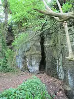
A similar rock cleft, the Chink, is about 200 yards north.
The feature was within the Bonchurch Landslip nature reserve, managed by Gift to Nature on behalf of the owners, the Isle of Wight Council.[5]
References
- ↑ Toogood, Darren (12 December 2023). "Devil Reclaims His Chimney – Council Confirms Islander's Worst Fears". Island Echo.
- ↑ Andrews, R. The Rough Guide to England, Rough Guides UK, 2011.
- ↑ Bird, E.C.F., The shaping of the Isle of Wight: with an excursion guide, Ex Libris Press, 1997
- ↑ Curtis, P., Walking on the Isle of Wight, Cicerone Press, 2013
- ↑ "Bonchurch Landslip". Gift to Nature. Retrieved 3 April 2017.
50°36′15″N 1°10′51″W / 50.6041°N 1.1807°W