Christopher Street | |||||||||||||||||||||||||||||||||||||||||||||||||||||||||||||||||||||||||||||||||||||||||||
|---|---|---|---|---|---|---|---|---|---|---|---|---|---|---|---|---|---|---|---|---|---|---|---|---|---|---|---|---|---|---|---|---|---|---|---|---|---|---|---|---|---|---|---|---|---|---|---|---|---|---|---|---|---|---|---|---|---|---|---|---|---|---|---|---|---|---|---|---|---|---|---|---|---|---|---|---|---|---|---|---|---|---|---|---|---|---|---|---|---|---|---|
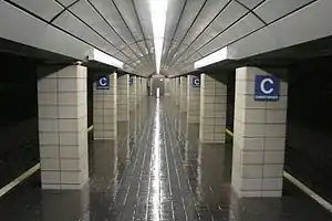
 The station platform as seen in 2007 | |||||||||||||||||||||||||||||||||||||||||||||||||||||||||||||||||||||||||||||||||||||||||||
| General information | |||||||||||||||||||||||||||||||||||||||||||||||||||||||||||||||||||||||||||||||||||||||||||
| Location | 137 Christopher Street Manhattan, New York | ||||||||||||||||||||||||||||||||||||||||||||||||||||||||||||||||||||||||||||||||||||||||||
| Coordinates | 40°44′01″N 74°00′25″W / 40.733602°N 74.006821°W | ||||||||||||||||||||||||||||||||||||||||||||||||||||||||||||||||||||||||||||||||||||||||||
| Owned by | Port Authority of New York and New Jersey | ||||||||||||||||||||||||||||||||||||||||||||||||||||||||||||||||||||||||||||||||||||||||||
| Line(s) | Uptown Hudson Tubes | ||||||||||||||||||||||||||||||||||||||||||||||||||||||||||||||||||||||||||||||||||||||||||
| Platforms | 1 island platform | ||||||||||||||||||||||||||||||||||||||||||||||||||||||||||||||||||||||||||||||||||||||||||
| Tracks | 2 | ||||||||||||||||||||||||||||||||||||||||||||||||||||||||||||||||||||||||||||||||||||||||||
| Connections | |||||||||||||||||||||||||||||||||||||||||||||||||||||||||||||||||||||||||||||||||||||||||||
| Construction | |||||||||||||||||||||||||||||||||||||||||||||||||||||||||||||||||||||||||||||||||||||||||||
| Accessible | No | ||||||||||||||||||||||||||||||||||||||||||||||||||||||||||||||||||||||||||||||||||||||||||
| History | |||||||||||||||||||||||||||||||||||||||||||||||||||||||||||||||||||||||||||||||||||||||||||
| Opened | February 25, 1908 | ||||||||||||||||||||||||||||||||||||||||||||||||||||||||||||||||||||||||||||||||||||||||||
| Passengers | |||||||||||||||||||||||||||||||||||||||||||||||||||||||||||||||||||||||||||||||||||||||||||
| 2018 | 967,725[1] | ||||||||||||||||||||||||||||||||||||||||||||||||||||||||||||||||||||||||||||||||||||||||||
| Rank | 12 of 13 | ||||||||||||||||||||||||||||||||||||||||||||||||||||||||||||||||||||||||||||||||||||||||||
| Services | |||||||||||||||||||||||||||||||||||||||||||||||||||||||||||||||||||||||||||||||||||||||||||
| |||||||||||||||||||||||||||||||||||||||||||||||||||||||||||||||||||||||||||||||||||||||||||
| |||||||||||||||||||||||||||||||||||||||||||||||||||||||||||||||||||||||||||||||||||||||||||
Christopher Street station is a station on the PATH system. Located on Christopher Street between Greenwich and Hudson Streets in the Greenwich Village neighborhood of Manhattan, New York City, it is served by the Hoboken–33rd Street and Journal Square–33rd Street lines on weekdays, and by the Journal Square–33rd Street (via Hoboken) line on weekends.
History

The station opened on February 25, 1908, as part of the Hudson and Manhattan Railroad extension between New Jersey and 33rd Street.[2] It received a renovation in 1986, during which the station was closed completely for a period of time.[3]
The station has long seen heavy traffic not only from passengers going to Jersey City and Hoboken, but also by Manhattan residents traveling from Greenwich Village to Midtown. The nearest subway station, Christopher Street-Sheridan Square, is a block away.[4]
The already busy station received even more passengers after the September 11, 2001 attacks, which resulted in the destruction of the World Trade Center PATH station. With Christopher Street becoming the closest PATH station to New Jersey, it started experiencing serious overcrowding. The Port Authority had to make it an exit-only station during the morning rush hour. The Port Authority planned to build a second entrance at Christopher and Bedford Street (a block and a half east of the current entrance), to ease overcrowding at the station, but local opposition caused the project to be canceled. Residents were concerned that the project would endanger the surrounding neighborhood's fragile historic buildings (through the vibrations that a major construction project would cause) and disrupt business and traffic.[5]
In 2002, Christopher Street station was used by an average of 7,400 people per day, or about 2.701 million per year. This was more than twice as many as the 1.314 million passengers that used the station during 2001.
Station layout
| G | Street level | Exit/entrance, buses |
| B1 | Mezzanine | Fare control |
| B2 Platform level |
Southbound | ← HOB–33 (weekdays 6a-11p) toward Hoboken (Terminus) ← JSQ–33 weekdays toward Journal Square (Newport) ← JSQ–33 (via HOB) weekends toward Journal Square (Hoboken) |
| Island platform | ||
| Northbound | HOB–33 weekdays toward 33rd Street (Ninth Street) → JSQ–33 (via HOB weekends) toward 33rd Street (Ninth Street) → | |
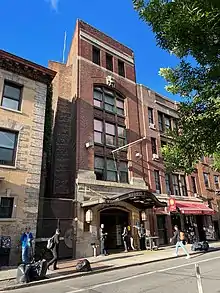
The station entrance is in its own free-standing building, with a restored marquee displaying the original "Hudson Tunnels" name adorning the entranceway. Passengers descend a narrow stairway with several curves before arriving at the southwest end of the narrow center island platform.[6]
Biff Elrod's mural "Ascent-Descent" (showing images of users of the PATH trains, ascending or descending the stairs) originally painted on site in August 1986 as a temporary installation for the Public Art Fund, and later purchased by Port Authority of New York and New Jersey, was restored in 1999.
References
- ↑ "PATH Ridership Report". Port Authority NY NJ. Port Authority of New York and New Jersey. 2022. Retrieved February 22, 2023.
- ↑ "TROLLEY TUNNEL OPEN TO JERSEY; President Turns On Power for First Official Train Between This City and Hoboken. REGULAR SERVICE STARTS Passenger Trains Between the Two Cities Begin Running at Midnight. EXERCISES OVER THE RIVER Govs. Hughes and Fort Make Congratulatory Addresses -- Dinner at Sherry's in the Evening" (PDF). The New York Times. February 26, 1908. Retrieved February 13, 2018.
- ↑ Anderson, Susan Heller; Dunlap, David W. (May 27, 1986). "New York Day by Day; PATH Recalls Early Years". The New York Times. ISSN 0362-4331. Retrieved July 20, 2016.
- ↑ "MTA Neighborhood Maps: West Village" (PDF). Metropolitan Transportation Authority. 2018. Retrieved October 1, 2018.
- ↑ Amateau, Albert (October 22, 2003). "A change of course on PATH". The Villager. Archived from the original on February 7, 2010. Retrieved August 16, 2009.
- ↑ Dougherty, Peter (2006) [2002]. Tracks of the New York City Subway 2006 (3rd ed.). Dougherty. OCLC 49777633 – via Google Books.
