 | |
|---|---|
| Bundesstraße 7 | |
 | |
| Route information | |
| Length | 530 km (330 mi) |
| Major junctions | |
| West end | Dutch border at Venlo |
| East end | Rochlitz near Chemnitz |
| Location | |
| Country | Germany |
| States | North Rhine-Westphalia, Hesse, Thuringia, Saxony |
| Highway system | |
| |
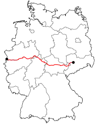
The Bundesstraße 7 (abbr. B7) is a German federal highway (Bundesstraße) that stretches from the Dutch border at Venlo in the West to Rochlitz near Chemnitz in the East. It is approximately 530 km (330 mi) long. Because of its western origin some stretches of the B 7 are designated as "Holländische Straße" (Dutch Road), e.g., in Kassel and Calden.
History
The former Reichsstraße 7 extended from Schmölln over Meerane, Glauchau, Chemnitz and Freiberg to Dresden, where it linked with the Reichsstraße 6. The former portion between Chemnitz and Dresden is now called the Bundesstraße 173.
The segment between Wuppertal and Hagen was constructed in 1788, making it one of the oldest roads in western Germany. The stretch connecting Iserlohn and Menden was built between 1816 and 1817.
Between Eisenach and Erfurt the B 7 follows the path of the former Via Regia. The original plan marked Dresden as he eastern terminus, however this portion was completed during the Third Reich and called the Bundesstraße 173.
New Developments
In some areas the Bundesstraße 7 is replaced by Autobahns. For example, between Hagen-Hohenlimburg and the former autobahn terminus in the eastern city of Iserlohn the B 7 becomes the Bundesautobahn 46. Also, between Kassel and Eisenach the B 7 is slated to be replaced by the new Bundesautobahn 44, the first piece of which was opened at Hessisch Lichtenau was in October 2005. Environmental concerns have been raised about the project, as the autobahn is proposed to run through the national park Meißner-Kaufunger Wald.
Since August 2005 heavy transport vehicles have been banned from a 157 km (98 mi) stretch of the B 7. The ban applies for a year and is enforced between Kassel at the A 7 junction and Wehretal. Vehicles originating or ending in the Kassel area are exempt from the ban.
Route / Junctions
| (14) | Büderich | |
| Neuss | ||
| Düsseldorf | ||
| Düsseldorf-Oberkassel | ||
| Theodor-Heuss Bridge | ||
| Düsseldorf-Kennedydamm | ||
| Düsseldorf-Mörsenbroich | ||
| Düsseldorf-Düsseltal | ||
| Düsseldorf-Grafenberg | ||
| (18) | Mettmann | |
| Wuppertal-Vohwinkel | ||
| (11) | Wuppertal-Dornap | |
| Wuppertal-Elberfeld-West | ||
| Wuppertal-Elberfeld | ||
| Wuppertal-Barmen | ||
| Wuppertal-Oberbarmen | ||
| (93) | Wuppertal-Langerfeld | |
| Schwelm | ||
| Ennepetal | ||
| Gevelsberg | ||
| Hagen | ||
| (44) | Hagen-Elsey | |
|
replaced by | ||
| (45) | Iserlohn-Letmathe | |
| (46) | Iserlohn-Oestrich | |
| (48) | Iserlohn-Seilersee | |
|
| ||
| (49) | Hemer | |
| Hemer | ||
| Menden (Sauerland) | ||
| Wickede-Wimbern | ||
| (62) | Arnsberg-Neheim | |
|
replaced by | ||
|
| ||
| (71) | Bestwig | |
| Bestwig | ||
| Brilon | ||
| Marsberg | ||
| (63) | Marsberg | |
| Scherfede | ||
| Warburg | ||
| Hesse | ||
| Calden | ||
| Anschluss | ||
| Espenau | ||
| Vellmar | ||
| Nieder-Vellmar | ||
| Kassel | ||
| (78) | Kassel-Ost 3-way interchange | |
| Kaufungen | ||
| Helsa | ||
| (76) | Hessisch-Lichtenau-West | |
| (78) | Hessisch Lichtenau-Ost | |
| (79) | Waldkappel | |
| Wehretal-Oetmannshausen | ||
| Wichmannshausen | ||
| Ringgau-Datterode | ||
| Ringgau-Netra | ||
| Ringgau-Rittmannshausen | ||
| Free State of Thuringia | ||
| Ifta | ||
| Junction | ||
| Creuzburg | ||
| Krauthausen-Deubachshof | ||
| (39a) | Eisenach-West | |
|
Re-routed to the A4 since 2006, in 2011 the old A4 becomes the B19 | ||
|
Replaced by | ||
|
| ||
| Gotha | ||
| (11) | Erfurt-Bindersleben | |
|
| ||
|
| ||
| (7) | Erfurt-Nord | |
| Erfurt | ||
| Mönchenholzhausen | ||
| Weimar | ||
| Umpferstedt | ||
| Jena | ||
| (22) | Eisenberg | |
|
| ||
|
| ||
| (60) | Ronneburg | |
| Schmölln | ||
| Altenburg | ||
| Free State of Saxony | ||
| Frohburg | ||
| (23) | Geithein | |
| Geithain | ||
| Rochlitz | ||
See also
External links
- http://www.strassenimpressionen.com - photographs of the Bundesstraße 7