Baza'i Gonbad
بزای گمبز | |
|---|---|
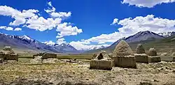 The historical gonbads in the village | |
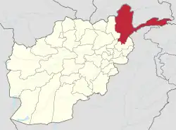
 Baza'i Gonbad Location in Afghanistan | |
| Coordinates: 37°8′0″N 74°0′0″E / 37.13333°N 74.00000°E | |
| Country | |
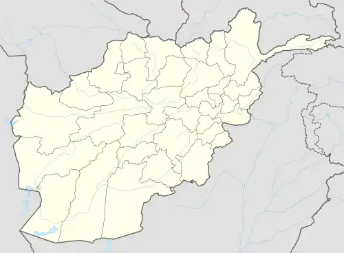
| Province | Badakhshan |
| District | Wakhan |
| Elevation | 12,910 ft (3,935 m) |
| Time zone | UTC+4:30 (AFT) |
Bozai Gumbaz or Baza'i Gonbad (Dari: بزای گمبز, lit. 'domes of the elders'[2]) is the site of a domed tomb (or gonbad) and nearby settlement of Kyrgyz and Wakhi herders in the Wakhan District of Badakhshan Province of Afghanistan.[3] It lies in the Little Pamir on the right bank of the Bozai River, near where it joins Wakhjir River to become the Wakhan River,[1][4] It is part of the Wakhan National Park and protected by the Afghan Armed Forces.[5] The Chaqmaqtin Lake is about 20 km (12 mi) to the northeast of Bozai Gonbad.
History
The area has been under the control of Afghanistan since the formation of the Durrani Empire in 1750. The eastern border of Wakhan District was settled with China's Qing dynasty during the reign of Ahmad Shah Durrani. The southern and northern borders came into existence during the Great Game in 1893. There is no evidence to indicate that the local Pamir Mountains had ever earlier supported permanent settlements. While debris of mud buildings and similar constructions can occasionally be found, they are generally seen as only indicating relatively recent occupation and have little if any evidence of a permanent character. The shrines and tombs scattered throughout the area are all of a comparatively recent character. There are also the remains of a small fort can be found near this location. It is said to have been built by Bozai, a Kyrgyz chief.[1]
Baza'i Gonbad was the scene of a minor incident during the Great Game. In 1891 the Russians sent a small military force to the area. The British Captain Francis Younghusband, in the course of his Pamir expedition, encountered the Russians at Baza'i Gonbad, and the Russians ordered him out of the area. The Russians subsequently apologised for the incident.[6]
Climate
Baza'i Gonbad is at extreme altitude, experiencing an alpine tundra climate (Köppen: ET), bordering on a subarctic climate (Dfc) that close to a monsoon-influenced subarctic climate (Dwc). The average annual temperature is −5.7 °C (21.7 °F) resulting in long, very cold winters and brief, cool summers.
| Climate data for Baza'i Gonbad (2009-present) | |||||||||||||
|---|---|---|---|---|---|---|---|---|---|---|---|---|---|
| Month | Jan | Feb | Mar | Apr | May | Jun | Jul | Aug | Sep | Oct | Nov | Dec | Year |
| Record high °C (°F) | −4 (25) |
0 (32) |
5 (41) |
10 (50) |
13 (55) |
19 (66) |
24 (75) |
21 (70) |
17 (63) |
14 (57) |
3 (37) |
−2 (28) |
24 (75) |
| Mean daily maximum °C (°F) | −13.1 (8.4) |
−9.9 (14.2) |
−4.4 (24.1) |
0.2 (32.4) |
4.3 (39.7) |
8.4 (47.1) |
13.3 (55.9) |
12.1 (53.8) |
9.0 (48.2) |
1.0 (33.8) |
−6.1 (21.0) |
−11.4 (11.5) |
0.3 (32.5) |
| Daily mean °C (°F) | −21.2 (−6.2) |
−18.1 (−0.6) |
−12.6 (9.3) |
−6.9 (19.6) |
−1.0 (30.2) |
4.2 (39.6) |
9.3 (48.7) |
8.4 (47.1) |
4.8 (40.6) |
−3.7 (25.3) |
−13.3 (8.1) |
−18.8 (−1.8) |
−5.7 (21.7) |
| Mean daily minimum °C (°F) | −29.0 (−20.2) |
−26.2 (−15.2) |
−20.7 (−5.3) |
−13.9 (7.0) |
−6.3 (20.7) |
0.0 (32.0) |
5.2 (41.4) |
4.7 (40.5) |
0.6 (33.1) |
−8.3 (17.1) |
−20.4 (−4.7) |
−26.1 (−15.0) |
−11.7 (11.0) |
| Record low °C (°F) | −46 (−51) |
−40 (−40) |
−38 (−36) |
−37 (−35) |
−23 (−9) |
−15 (5) |
−8 (18) |
−6 (21) |
−11 (12) |
−26 (−15) |
−33 (−27) |
−44 (−47) |
−46 (−51) |
| Average precipitation mm (inches) | 16.3 (0.64) |
35.6 (1.40) |
53.0 (2.09) |
62.9 (2.48) |
57.9 (2.28) |
63.9 (2.52) |
84.1 (3.31) |
99.3 (3.91) |
91.8 (3.61) |
36.8 (1.45) |
16.6 (0.65) |
10.7 (0.42) |
628.9 (24.76) |
| Average relative humidity (%) | 78 | 79 | 77 | 73 | 63 | 56 | 51 | 55 | 50 | 56 | 71 | 74 | 65 |
| Source: World Weather Online[7] | |||||||||||||
Economy
_(14802941813).jpg.webp)
The economy of the area is based on agriculture, trade, and tourism. In order to improve the local economy, the government of Afghanistan is building a road to Sarhadd in the southwest and Wakhjir Pass (Afghanistan–China border) in the east.[8][9][10][11] One of the main attractions in Bazai Gonbad is Chaqmaqtin Lake, which is a short distance to the northeast.
References
- 1 2 3 Adamec, Ludwig W., ed. (1972). Historical and Political Gazetteer of Afghanistan. Vol. 1. Graz, Austria: Akadamische Druck-u. Verlangsanstalt. p. 47.
- ↑ Mock and O'Neill (2004): Expedition Report
- ↑ "In Icy Tip of Afghanistan, War Seems Remote". The New York Times. 27 October 2010. Retrieved 20 December 2022.
- ↑ "NGA GeoName Database". National Geospatial-Intelligence Agency. Archived from the original on 22 July 2010. Retrieved 20 July 2010.
- ↑ "Cabinet orders military deployment, services in Wakhan valley". Pajhwok Afghan News. 20 November 2022. Retrieved 29 November 2023.
- ↑ Riddick, John (2006). The history of British India. Praeger Pub Text. p. 82. ISBN 978-0-313-32280-8.
- ↑ "Baza'i Gonbad, World Weather Online". Retrieved 22 September 2022.
- ↑ "Construction of Wakhan road in Badakhshan has started: Mujahid". Ariana News. 29 November 2023. Retrieved 29 November 2023.
- ↑ "Ministry: Road Between Badakhshan and China Will Be Completed in 3 Months". TOLOnews. 27 November 2023. Retrieved 29 November 2023.
- ↑ "Wakhan Corridor Important for Trade: ACCI". TOLOnews. 29 November 2023. Retrieved 29 November 2023.
- ↑ "Traders urge govt to resume work on Wakhan corridor". Pajhwok Afghan News. 28 November 2023. Retrieved 29 November 2023.
External links
- We meet FORGOTTEN PEOPLE of Afghanistan on YouTube (Nov. 26, 2023)
- On the Road - Pamir Heights of Badakhshan on YouTube (TOLO TV, Nov. 2, 2023)
- Satellite map at Maplandia.com