Bewell's Cross is a lost monument which marked the boundary of Bristol.[1] The name 'Bewel' goes back at least as far as 1188, when it is referred to in a charter of King John as one of four points marking the limits of Bristol.[2] The placenames specialist, Richard Coates,[3] suggests that 'Bewell' is probably derived from the Old English for 'bee well' - i.e. a spring or well associated with bees.[4] However, he notes that is just possible that the name represents a pruning of 'Beowolf's Well', given that a Bristolian called Elias or Elys recorded in about 1270 with the surname Beowolf.
Bewell's Cross itself is first recorded in September 1373, during the perambulation of the boundaries set down to define the newly established county of Bristol. The survey mentions the Cross twice, noting that those perambulating the boundary should go up the highway to Henbury 'as far as a certain cross called Bewellescrosse' (quandam crucem vocatam Bewellescross), and from thence further northwards as far as a stone fixed hard by the spring of Bewelle.'[5] It then goes on to say that the boundary returned back south along 'the same king’s highway as far as another stone fixed hard by (lit. 'prope' = close to) the aforesaid cross on the eastern part of the same cross'.[6]
Bewell's Cross and the associated gallows and boundary stone are mentioned in William Worcester's 1480 topographical survey of Bristol. This includes a section on the road going up from 'the parish church of St Michael, as far as the tall stone appointed as the boundary of the franchise of the town of Bristol, near the cross and the site of the gallows for the legal punishment, by hanging and putting to death, for traitors and thieves'.[7]


The cross stood in what became known as Gallow's Field at the top of St Michael's Hill, the former principal road from Bristol to Westbury-on-Trym, Henbury and Wales via the Severn ferry at Aust. This is where the Bristol's 'Marian Martyrs' were burnt in 1556-7, events described in John Foxe's Book of Martyrs (1563).[8] The executions are memorialised in what is now Cotham Church.[9]
.png.webp)
Seventeenth-century references in Bristol's financial accounts include payments for 'a new double-ladder for the gallows' in 1625.[10] This allowed the hangman to climb one ladder, while the condemned climbed the other, removing the need for a cart. The convict was required to walk to their execution.
A 1736 survey of the county boundaries suggests the Bewell's Cross was still extant, in that it mentions a boundary stone (no. 23) 'on the High Bank, over-against the Cross'.[11] The cross is not depicted on the 1743 map by John Rocque.[12] However, the boundary stone is, both on Rocque's 1743 map and on early nineteenth century maps, including Ashmead's maps of 1828 and 1855.[13] These indicate that boundary stone 23 was located in the middle of what is now Cotham Road, about fifteen metres from the junction with St Michael's Hill.[14]
Writing in 1789, the historian, William Barrett, noted that 'Bewell or Bewell's Cross then called is that where the criminals now usually pray before their execution at St. Michael's-hill gallows.' [15] At another point, he refers to 'Bewell in the highway to Henbury where was an old cross called Bewell's cross near St. Michael's hill'.[16] Barrett's use of the past tense suggests that the cross had been removed, or was broken, by his time. Executions at this site remained common during the eighteenth century, the historian John Latimer recording the details of 138 people who were hanged there over the course of the century.[17] He did not regard his list as a full record of the executions. Latimer also observed that most of the condemned were buried in St Michael's churchyard, being recorded in the parish burial register for the church.
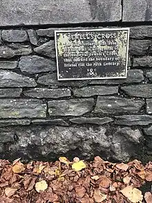
The base of Bewell's Cross was dug up in 1829 when Cotham New Road (now Cotham Road) was laid out, cutting through the former Gallows Field. Part of the base was subsequently incorporated into the wall running along the south side of the new road.[18][19] This later became part of the wall enclosing Highbury Congregational Chapel (now Cotham Church), built in 1842-3.[20] The historian John Latimer was sceptical about the provenance of the stone because 'Roque's large map of the city, dated 1741, shows the cross to have stood nearly one hundred yards farther to the north-west.'[21] This appears to be a misreading by Latimer of 'Bewell's Croft' on Rocque's maps, which was the name of a field lying north west of the gallows.[22] The stone itself still forms part of the wall, accompanied by a plaque noting it to be 'a fragment of the Medieval Bewell's Cross'.[23]
Bewell's Cross may have been historically confused with Bewys Cross in Kingsweston, also now within the boundaries of the city of Bristol.
References
- ↑ Richard Coates, 'Two Bristol Crosses: Bewell’s Cross, St Michael on the Mount Without Parish, and Bewys Cross, Kingsweston', Transactions of the Bristol & Gloucestershire Archaeological Society 132 (2014), 217–222
- ↑ N. D. Harding (ed.), Bristol Charters, 1155-1373 (Bristol Record Society publications, Vol. I, Bristol, 1930), pp. 8-9.
- ↑ 'Richard Coates', UWE
- ↑ Coates, 'Two Bristol Crosses', pp. 219-22.
- ↑ Norah Dermott Harding (ed.), Bristol Charters, 1155-1373 (Bristol Record Society publications, Vol. I, Bristol, 1930), p. 157.
- ↑ Norah Dermott Harding (ed.), Bristol Charters, 1155-1373 (Bristol Record Society publications, Vol. I, Bristol, 1930), p. 157.
- ↑ Frances Neale (ed.), William Worcestre: The Topography of Medieval Bristol (Bristol Record Society Publications, Vol. LI, Bristol, 2000), pp. 86-7
- ↑ John Foxe, The acts and monuments of the church, containing the history and sufferings of the martyrs, ed. Michael Hobart Seymour (1855), p. 976
- ↑ K. G. Powell, The Marian Martyrs and the Reformation in Bristol (Bristol Historical Association, 1972), pp. 10, 17.
- ↑ Latimer, John, The Annals of Bristol in the Seventeenth Century (Bristol, 1900), p. 91.
- ↑ Anon., Bristol. The City Charters...To which are added, The Bounds of the City, by Land, with the exact Distances from Stone to Stone, all round the City (Felix Farley, Bristol, 1736)
- ↑ John Rocque, Plan of the City of Bristol (1743)
- ↑ 'Know your place: Bristol' website. Accessed 21 Nov. 2023
- ↑ Grid reference: 51°27'44.4"N 2°36'11.2"W
- ↑ William Barrett, The History and Antiquities of the City of Bristol (Bristol 1789), p. 665, note
- ↑ William Barrett, The History and Antiquities of the City of Bristol (Bristol 1789), p. 104, note
- ↑ John Latimer, The Annals of Bristol in the Eighteenth Century (Bristol, 1893), pp. 136-8, 294.
- ↑ Latimer, John, The Annals of Bristol in the Nineteenth Century (Bristol, W. & F. Morgan, 1887), p. 134
- ↑ Bristol Archives, 45934/18, 'A Bristol Calendar containing brief notices of such events as have taken place from July 1824 to December 1835, compiled by Daniel Vickery', p. 151
- ↑ 'Cotham Church, Cotham Road', Historic England website. Accessed 21 Nov. 2023.
- ↑ Latimer, John, The Annals of Bristol in the Nineteenth Century (Bristol, W. & F. Morgan, 1887), p. 134
- ↑ John Rocque, Plan of the City of Bristol (1743)
- ↑ Photograph: 'Fragment of Bewell's Cross'