Bener Meriah Regency
Kabupaten Bener Meriah | |
|---|---|
 Seal | |
| Motto: Musara Pakat | |
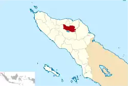 Location within Aceh | |
| Coordinates: 4°45′N 97°00′E / 4.750°N 97.000°E | |
| Country | |
| Region | Sumatra |
| Province | |
| Established | 2003 |
| Regency seat | Simpang Tiga Redelong |
| Government | |
| • Regent | Ahmadi |
| • Vice Regent | Abuya Sarkawi |
| Area | |
| • Total | 1,907.40 km2 (736.45 sq mi) |
| Population (mid 2022 estimate) | |
| • Total | 168,690 |
| • Density | 88/km2 (230/sq mi) |
| [1] | |
| Time zone | UTC+7 (IWST) |
| Area code | (+62) 643 |
| Website | benermeriahkab.go.id |

Bener Meriah Regency (Indonesian: Kabupaten Bener Meriah) is a regency in Aceh Special District, Indonesia. It is located on the island of Sumatra. The regency covers an area of 1,941.61 square kilometres and it had a population of 122,277 at the 2010 census[2] and 161,342 at the 2020 census;[3] the official estimate as at mid 2022 was 168,690 - comprising 85,520 males and 83,170 females.[1] Its capital is the town of Simpang Tiga Redelong. Until 2003 the present territory of this regency was the northern part of the Central Aceh Regency, from which it was split away.
Administrative districts
As at the 2010 census, the regency was divided administratively into seven districts (kecamatan). However, since 2010 three additional districts - Bener Kelipah, Gajah Putih and Mesidah - have been created by the division of existing districts. The ten districts are listed below with their areas and their populations at the 2010 census[2] and the 2020 census,[3] together with the official estimates as at mid 2022.[1] The table also includes the locations of the district administrative centres, the number of villages (gampong) in each district, and its post code.
| Kode Wilayah | Name of District (kecamatan) | Area in km2 | Pop'n census 2010 | Pop'n census 2020 | Pop'n estimate mid 2022 | Admin centre | No. of villages | Post code |
|---|---|---|---|---|---|---|---|---|
| 11.17.07 | Timang Gajah | 98.28 | 25,315 | 21,880 | 22,563 | Lampahan | 30 | 24555 |
| 11.17.10 | Gajah Putih | 72.57 | (a) | 9,326 | 9,630 | Reronga | 10 | 24553 |
| 11.17.01 | Pintu Rime Gayo | 223.56 | 10,155 | 14,752 | 15,705 | Blang Rakal | 23 | 24554 |
| 11.17.05 | Bukit | 110.95 | 21,781 | 29,489 | 30,970 | Simpang Tiga Redelong | 40 | 24581 |
| 11.17.06 | Wih Pesam | 66.28 | 19,861 | 24,938 | 25,811 | Pante Raya | 27 | 24580 |
| 11.17.04 | Bandar | 82.10 | 25,931 | 28,261 | 29,368 | Pondok Baru | 35 | 24582 |
| 11.17.08 | Bener Kelipah | 26.75 | (a) | 4,984 | 5,180 | Gunung Musara | 12 | 24583 |
| 11.17.03 | Syiah Utama | 814.63 | 4,525 | 2,147 | 2,344 | Samar Kilang | 14 | 24586 |
| 11.17.09 | Mesidah | 286.83 | (a) | 5,199 | 5,647 | Wer Tingkem | 15 | 24584 |
| 11.17.02 | Permata | 159.66 | 14,709 | 20,366 | 21,482 | Buntul | 27 | 24585 |
| Totals | 1,941.61 | 122,277 | 161,342 | 168,690 | Simpang Tiga Redelong | 233 |
Note: (a) the 2010 population of these three districts is included in the figure for the preceding districts, from which they were subsequently split away.
Bener Meriah Regency covers the former northern part of the Central Aceh Regency, and is bordered by Bireuen, North Aceh and Central Aceh regencies.
References
External links
- Bener Meriah Regency (in Indonesian)
- UU RI No.41 Tahun 2003 (in Indonesian)
Regencies and cities of Aceh | ||
|---|---|---|
Capital: Banda Aceh | ||
| Regencies |  | |
| Cities | ||
4°45′N 97°00′E / 4.750°N 97.000°E