Kensaleyre
| |
|---|---|
 Carn Liath in Kensaleyre. This Carn Liath is one of many features of that name throughout the Scottish highlands. It is a four-metre-high (13 ft) chambered cairn. | |
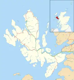 Kensaleyre Location within the Isle of Skye | |
| OS grid reference | NG422514 |
| Council area | |
| Country | Scotland |
| Sovereign state | United Kingdom |
| Post town | Snizort |
| Postcode district | IV51 9 |
| Police | Scotland |
| Fire | Scottish |
| Ambulance | Scottish |
| UK Parliament | |
| Scottish Parliament | |
Kensaleyre (Scottish Gaelic: Ceann Sàil Eighre) is a scattered crofting township, part of a group of settlements clustered around the A87 road on the shore of Loch Snizort Beag[1][2] on the Trotternish peninsula of the island of Skye in the Highlands and Islands of Scotland. It is in the council area of Highland.
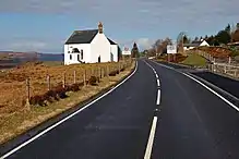
Snizort Parish Church, Kensalyre
References
- ↑ Microsoft; Nokia (7 March 2017). "Kensaleyre" (Map). Bing Maps. Microsoft. Retrieved 7 March 2017.
- ↑ Gittings, Bruce; Munro, David. "Kensaleyre". The Gazetteer for Scotland. School of GeoSciences, University of Edinburgh and The Royal Scottish Geographical Society. Retrieved 17 August 2018.
Wikimedia Commons has media related to Kensaleyre.
This article is issued from Wikipedia. The text is licensed under Creative Commons - Attribution - Sharealike. Additional terms may apply for the media files.