
The A847 at Uiskentuie
 | |
|---|---|
| Route information | |
| Length | 14.7 mi[1] (23.7 km) |
| Major junctions | |
| North end | Bridgend 55°46′55″N 6°14′56″W / 55.7819°N 6.249°W |
| A846 | |
| South end | Portnahaven 55°40′51″N 6°30′23″W / 55.6808°N 6.5063°W |
| Location | |
| Country | United Kingdom |
| Constituent country | Scotland |
| Road network | |
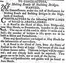
Advertisement for construction from the Caledonian Mercury 18 November 1805
The A847 road is one of the two principal roads of Islay in the Inner Hebrides off the west coast of mainland Scotland.
It connects Bridgend, at a junction with the A846 road, with Portnahaven at the southern end of the Rinns of Islay peninsula. It is some 14+1⁄2 miles (23 km) long.
The road was completed in 1806 following the route surveyed by John Langlands of Campbeltown.[2]
Settlements on or near the A847
North to South
- Bridgend
- Blackrock
- Bruichladdich
- Port Charlotte
- Nerabus (Nereabolls)
- Easter Ellister
- Portnahaven
References
- ↑ "Driving directions to High St/A847". Google Maps. Retrieved 23 September 2013.
- ↑ Walker, Frank Arneil (2005). The Buildings of Scotland. Argyll and Bute. Yale University Press. p. 551. ISBN 9780300096705.
A roads in Zone 8 of the Great Britain road numbering scheme | ||
|---|---|---|
This article is issued from Wikipedia. The text is licensed under Creative Commons - Attribution - Sharealike. Additional terms may apply for the media files.