Ataşehir | |
|---|---|
District and municipality | |
_in_Istanbul.png.webp) | |
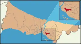 Map showing Ataşehir District in Istanbul Province | |
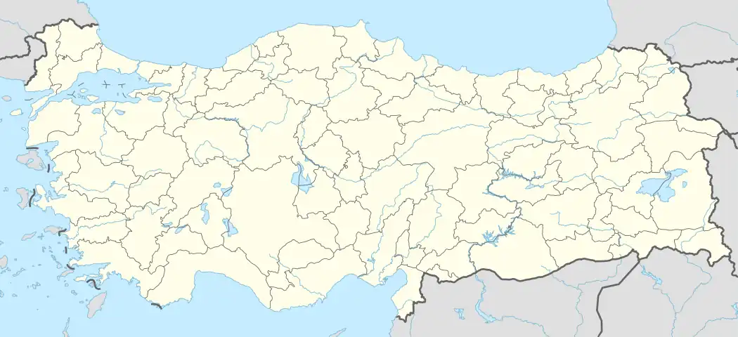 Ataşehir Location in Turkey 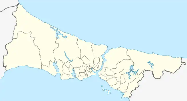 Ataşehir Ataşehir (Istanbul) | |
| Coordinates: 40°59′00″N 29°07′40″E / 40.98333°N 29.12778°E | |
| Country | Turkey |
| Province | Istanbul |
| Government | |
| • Mayor | Battal İlgezdi (CHP) |
| Area | 25 km2 (10 sq mi) |
| Population (2022)[3] | 423,127 |
| • Density | 17,000/km2 (44,000/sq mi) |
| Time zone | TRT (UTC+3) |
| Area code | 0216 |
| Website | www |
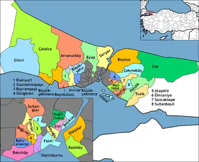
Ataşehir is a municipality and district of Istanbul Province, Turkey.[4][5] Its area is 25 km2,[6] and its population is 423,127 (2022).[3] It is located at the junction of the O-2 and O-4 motorways on the Anatolian (Asian) side of Istanbul. Its neighbours are the districts of Ümraniye to the north, Sancaktepe to the northeast, Maltepe to the east, Kadıköy to the south and Üsküdar to the west.
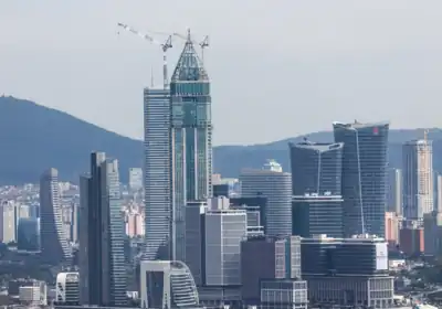
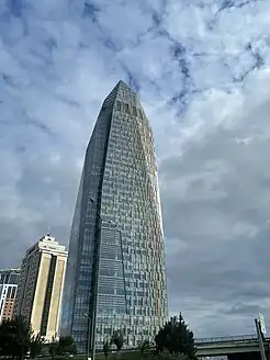
Since 2023, Ataşehir is home to the Istanbul Financial Center (IFC), where the new headquarters of the state-owned Turkish banks, including the Central Bank of the Republic of Turkey, Ziraat Bank, Halkbank and VakıfBank, are located.[7] Until 2023, the headquarters of these banks were in Ankara. As of 2024, the tallest buildings in Ataşehir are the 352 m (1,154 ft 10 in) Turkish Central Bank Tower,[8][9][10] which is followed by Metropol Istanbul Tower A (70 floors / 301 metres including its twin spires).[11][12][13]
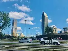
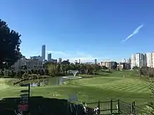
Unlike in Başakşehir, another satellite city (on the western part of the European side of Istanbul), no single-family house types were designed for Ataşehir's residential projects. Most buildings in Ataşehir are high-rise towers, while some of them (especially around the main public squares in the district) are among Istanbul's and Turkey's tallest skyscrapers.
The M4 line (Kozyatağı and Yenisahra stations) of the Istanbul Metro serves the district.
History
In 2008 the district Ataşehir was created from parts of the districts Kadıköy, Üsküdar, Ümraniye and Kartal.[14][15]
The original housing development of Ataşehir was designed to include 18,000 high-rise condominiums offering luxury residences for 80,000 people with higher incomes. Ataşehir was awarded the Habitat prize in 2005.[16]
As of 2006, 8596 housing units were present within the site, housing approximately 35,000 people. New investments still continue on the last empty sites of the district.
Politics and administration
Ataşehir Municipality has been founded in 2009. The municipal building and the district's security directorate are located in the neighborhood of Barbaros.[17][18] Ataşehir Municipality has 24 subordinate directorates.[19]
| Date | Mayor | Party | % of votes |
| 2009 | Battal İlgezdi | CHP | 41.69 [20] |
| 2014 | Battal İlgezdi | CHP | 49.80 [21] |
| 2019 | Battal İlgezdi | CHP | 51.39 [22] |
| Date | Party | % of votes |
|---|---|---|
| 2011 | AKP | 45.64 |
| June 2015 | AKP | 37.45 |
| November 2015 | AKP | 43.60 |
| 2018 | AKP | 37.51 |
Composition
There are 17 neighbourhoods in Ataşehir District:[24]
- Aşık Veysel
- Atatürk
- Barbaros
- Esatpaşa
- Ferhatpaşa
- Fetih
- İçerenköy
- İnönü
- Kayışdağı
- Küçükbakkalköy
- Mevlana
- Mimar Sinan
- Mustafa Kemal
- Örnek
- Yeni Çamlıca
- Yenisahra
- Yenişehir
Economy
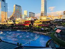
Ataşehir is a business and trading centre and hosts the headquarters and offices of numerous companies. Opened in 2023, Istanbul Financial Center (IFC)[25] in the Ataşehir district brings together the new headquarters of the Central Bank of the Republic of Turkey and other state-owned banks, such as Ziraat Bank, VakıfBank and Halkbank.
Transportation
Ataşehir can be reached with the M4 line (Kozyatağı and Yenisahra stations) of the Istanbul Metro.
For private car owners the subdivision is: 20-30 minutes from the Fatih Sultan Mehmet Bridge; 3 minutes from Highway D-100 and the İzmit-Ankara Trans-European Motorway (TEM); 20 minutes from Bağdat Avenue, the upper-class high street of Kadıköy district; and 30-40 minutes from Sabiha Gökçen Airport, the second international airport of Istanbul.
Sports

Ülker Sports and Event Hall, home of Fenerbahçe's basketball team, is in Ataşehir.
The women's football club Ataşehir Belediyespor plays in the Turkish Women's First Football League. The team was the champion in the 2010–11 and 2011–12 seasons.
Ataşehir Golf Club [tr] has a 6-hole course that was opened in 2017.[26][27] The club also regularly hosts footgolf events.[28]
Education
Yeditepe University, one of the largest private universities in Turkey, is located in Ataşehir. Fenerbahçe University is also located in Ataşehir.
Libraries
Ahmet Telli Çocuk ve Halk Kütüphanesi is a public library in the district.
Climate
The district of Ataşehir has a Mediterranean climate (Csa/Cs) according to both Köppen and Trewartha climate classifications, with cool winters and warm to hot summers.
It is in USDA hardiness zone 9a and AHS heat zone 3.[29]
| Climate data for Sarıgazi[lower-alpha 1] | |||||||||||||
|---|---|---|---|---|---|---|---|---|---|---|---|---|---|
| Month | Jan | Feb | Mar | Apr | May | Jun | Jul | Aug | Sep | Oct | Nov | Dec | Year |
| Mean daily maximum °C (°F) | 8.5 (47.3) |
9.2 (48.6) |
11.0 (51.8) |
16.2 (61.2) |
20.9 (69.6) |
25.5 (77.9) |
27.6 (81.7) |
27.4 (81.3) |
24.4 (75.9) |
19.3 (66.7) |
15.1 (59.2) |
11.0 (51.8) |
18.0 (64.4) |
| Daily mean °C (°F) | 5.5 (41.9) |
6.1 (43.0) |
7.4 (45.3) |
11.8 (53.2) |
16.1 (61.0) |
20.5 (68.9) |
22.7 (72.9) |
22.8 (73.0) |
19.8 (67.6) |
15.5 (59.9) |
11.6 (52.9) |
8.0 (46.4) |
14.0 (57.2) |
| Mean daily minimum °C (°F) | 2.4 (36.3) |
2.9 (37.2) |
3.7 (38.7) |
7.3 (45.1) |
11.3 (52.3) |
15.4 (59.7) |
17.8 (64.0) |
18.2 (64.8) |
15.2 (59.4) |
11.6 (52.9) |
8.1 (46.6) |
4.9 (40.8) |
9.9 (49.8) |
| Average precipitation mm (inches) | 111 (4.4) |
75 (3.0) |
72 (2.8) |
52 (2.0) |
37 (1.5) |
28 (1.1) |
26 (1.0) |
36 (1.4) |
51 (2.0) |
82 (3.2) |
95 (3.7) |
130 (5.1) |
795 (31.2) |
| Source: [30] | |||||||||||||
Notes
- ↑ Sarıgazi is in the district of Sancaktepe; however, it is the closest station to Ataşehir climatically.
References
- "Istanbul Financial Center". Retrieved 13 January 2024.
- ↑ "Istanbul Financial Center". Retrieved 13 January 2024.
- 1 2 "Address-based population registration system (ADNKS) results dated 31 December 2022, Favorite Reports" (XLS). TÜİK. Retrieved 12 July 2023.
- ↑ Büyükşehir İlçe Belediyesi, Turkey Civil Administration Departments Inventory. Retrieved 12 July 2023.
- ↑ "İstanbul'un yeni 'İlçe' haritası çizildi" (in Turkish). Municipality of Istanbul. 2008. Archived from the original on 2016-04-16. Retrieved 2009-08-11.
- ↑ "İl ve İlçe Yüz ölçümleri". General Directorate of Mapping. Retrieved 12 July 2023.
- ↑ Tuba Ongun (17 April 2023). "Istanbul Finance Center opens with inauguration of banking section". Anadolu Agency.
- ↑ "Central Bank of the Republic of Turkey". skyscraperpage.com. Retrieved 20 May 2023.
- ↑ "Central Bank of the Republic of Turkey". skyscrapercenter.com. Retrieved 20 May 2023.
- ↑ "Central Bank of the Republic of Turkey Campus Phase I-II". limak.com.tr. Retrieved 15 May 2023.
- ↑ "Metropol İstanbul". gapinsaat.com. Retrieved 16 May 2023.
- ↑ "Image of Metropol Istanbul Towers".
- ↑ "Image of Metropol Istanbul Towers and the Ataşehir district". Retrieved 28 November 2020.
- ↑ Kanun No. 5747, Resmî Gazete, 22 March 2008.
- ↑ "İl İdaresi ve Mülki Bölümler Şube Müdürlüğü İstatistikleri - İl ve İlçe Kuruluş Tarihleri" (PDF) (in Turkish). p. 42. Retrieved 26 July 2023.
- ↑ "Ataşehir de minareyi çalan kılıfını hazırlamış!".
- ↑ Ataşehir İlçe Emniyet Müdürlüğü, 28 Septembre 2014
- ↑ "Ataşehir Belediyesi".
- ↑ Müdürlükler
- ↑ 2009 local election results
- ↑ 2014 local election results
- ↑ 2019 local election results
- ↑ "Istanbul Financial Center". Retrieved 13 January 2024.
- ↑ Mahalle, Turkey Civil Administration Departments Inventory. Retrieved 12 July 2023.
- ↑ "Istanbul Financial Center". Retrieved 13 January 2024.
- ↑ "Kentsel dönüşümden golf sahası çıktı". www.sozcu.com.tr (in Turkish). Archived from the original on 19 March 2020. Retrieved 19 March 2020.
- ↑ "Hakkımızda". atasehirgolf.com. Archived from the original on 19 March 2020.
- ↑ fanatik. "Ataşehirde Futgolf heyecanı!". Fanatik. Archived from the original on 19 March 2020. Retrieved 19 March 2020.
- ↑ "Bitki Soğuğa ve Sıcağa Dayanıklılık". www.mgm.gov.tr. Retrieved 2021-04-28.
- ↑ "Istanbul / Sar?gazi - Weather History & Climate Data - Meteostat". meteostat.net. Retrieved 2021-06-20.
- "Information on Ataşehir district" (in Turkish). Governorship of Istanbul. 2009. Archived from the original on 2010-02-21. Retrieved 2009-08-11.
External links
- District municipality's official website (in Turkish)
- Library website